Geographic context and climate challenges
The Mediterranean basin, particularly the Provence-Alpes-Côte d’Azur (PACA) region, is highly vulnerable to climate change. Since 1960, the Alpes-Maritimes area has experienced a temperature increase of 1.6°C. Extreme weather events such as heat waves are becoming longer, more intense, and more frequent. The likelihood of centennial floods has doubled and sea level rise is also accelerating, from 2.1mm per year in the 1990s to 4.4mm per year today, with projections indicating a rise of 1cm per year by 2050. Even with carbon neutrality, sea levels could rise by 40cm to 84cm by 2100, and possibly up to 1.7m. These changes are primarily driven by rising temperatures, increasing the risks of flooding, coastal erosion, and saltwater intrusion. Additionally, the formation of “medicanes,” like the one in 2011 that brought 900mm of rain to the Gard, is becoming more likely with a 3°C rise in sea temperatures.
These changes, combined with the overexploitation of natural resources, intensive urbanisation and mass tourism, create significant environmental, social, and economic challenges for the region. This underscores the need to calibrate coastal infrastructure to remain viable and attractive over the long term, while considering the compounded impacts of climate change on the region.
CASAdapt addresses various institutional and regulatory challenges to foster climate adaptation. Key questions include the social acceptance of climate change measures within the Sophia Antipolis Agglomeration Community (CASA), and amongst local communities and decision-makers, and understanding the obstacles to achieve an ecological transition. CASAdapt aims to ensure cohesion between plans and strategies at local, national and international level. The project seeks to create synergies and dialogue between scientific research and local policies, but also to involve citizens in the collective foresight analysis activities.
Objectives
The CASadapt project aims to create a bridge between scientific research and local policies. It compares directives/strategies/action plans for anticipating and adapting to climate change at the local (CASA) and regional (Provence-Alpes-Côte d’Azur and Mediterranean region) levels. In order to co-construct these adaptation pathways for the Mediterranean basin while encouraging the mitigation of greenhouse gas emissions and taking into account the specificities of the Côte d’Azur, the CASadapt action-research project—jointly led by Plan Bleu, GREC-SUD (led by AIR Climat), the Provence-Alpes-Côte d’Azur Region, the Sophia Antipolis Agglomeration Community and its Development Council—undertook a coordinated territorial foresight exercise focused on three pilot coastal municipalities: Vallauris Golfe-Juan, Antibes, and Villeneuve-Loubet. The participatory workshops convened local stakeholders (scientists, institutional, socio-economic, and associative actors) to connect various local and national skills and expertise on the issue of coastal adaptation to climate change.
The project’s objective is to create a foresight and multi-stakeholder participation dynamic around the issue of adapting coastal areas to climate change. Indeed, to guarantee the social acceptance of adaptation measures, the involvement of local players is essential. The CASA is built in a very technology-oriented history based on engineering solutions due to the creation of the Sophia Antipolis technopole, which has resulted in stakeholders taking a very “techno-solutionist” approach to the type of adaptation measures chosen. That is why raising awareness by involving decision-makers and accompanying them in the implementation of regulations is a first step to ensure that the measure is implemented effectively, and that the people responsible for it are fully convinced.
The development, monitoring and analysis of a participatory foresight methodology will enable the project to be replicated in other areas.
Adaptation measures implemented in the case
CASAdapt consists in promoting societal adaptation measures by redefining governance models associated to land use planing.
Through public consultations, this project aims to promote collaborative spatial planning methods and imagine collectively new pathways for adaptation measures, considering the specific needs and community expectations of the CASA territory. In other terms, to pave the way to operational solutions, whether based on green or grey options if necessary, based and the latest scientific knowledge and socio-ecosystems approaches.
Solutions
Process and Genesis: Plan Bleu as a Regional Activity Center (RAC) of UN-Environment/MAP is working on foresight studies, as one of its 3 pillars of expertise. A regional exercise is ongoing (Med2050) as well as sub-national ones in climate hotspots in Morocco, Montenegro and Lebanon (GEF MedProgramme). In that context, Plan Bleu decided to develop a project in France, on the CASA (Communauté d’agglomération Sophia Antipolis) to work with local communities and decision makers to better adapt the area to climate change impacts.
During the prospective workshops led within the project, gathering Development council members and CASA officers, various adaptation solutions were identified. It should be noted that their integration to the territorial coherence scheme – an important spatial planning tool that falls within the remit of the public establishment of intercommunal cooperation is still pending.
To address the risks of marine submersion, coastal erosion and flooding in the Villeneuve Loubet area, the working groups came up with several evolutionary scenarios, including a reorganization of the area’s traffic plan by relocating the railway line and industrial zones to renaturalize the coastline and changing the nature of the current TER train line into a tramway and developing soft mobility along the line.
In the Golfe-Juan, Cap d’Antibes and Vallauris Sector, to respond to strong anthropogenic pressures and major marine biodiversity issues, the working group proposed a plan with different steps for the medium and long term. By 2030, it is envisaged that the beach, then the road and then the railroad will disappear due to climatic events, as sea levels rise, the pebble beach disappears, followed by the coastal road. During this time, it is important to defend the railroad until 2060 (when the new line is completed). Then, it will be possible to transform its use, and to question the redevelopment of the buildings and activities located behind it – to proceed with an overall development of the coastline, of the built-up area, with a green corridor and restoration of the wetlands, while addressing the issues of the economic model around tourism. It’s no longer just a question of a strategic retreat from the beach, but of giving the sea back its natural space.
Regarding the fluvial area with the mouths of the Brague and Loup rivers and their catchment areas, the main threats are the flooding risks. The working groups have identified solutions alternating between “water retention” and “renaturation and expansion zones”, overgrowing certain areas to retain water and renaturing deltas. This renaturation approach was highlighted as a priority solution based on the remarkable biodiversity of the basin.
The CASadapt project used a concerted territorial foresight approach to identify and design adaptation options and solutions for the CASA. The process involved comprehensive workshops that brought together scientists, institutional representatives, socio-economic actors, and civil society. Participatory mapping and narrative techniques were used to territorialize climate projections, identify vulnerabilities, and envision adaptation trajectories. The first workshop focused on diagnosing climate impacts and mapping vulnerabilities, while the second workshop translated these findings into operational adaptation measures. Identified solutions included enhancing coastal resilience, integrating sustainable land-use practices and the appropriate relocation of human activities. Technical aspects involved detailed climate projections and participatory maps.
The expected added value includes enhanced local resilience to climate change, informed by a robust, participatory diagnosis and evidence-based recommendations. The engagement of a wide range of stakeholders ensures that the solutions are well-grounded in local realities and supported by diverse expertise.
The CASadapt project aims to enhance the dialogue between various governance levels on climate change adaptation. By aligning the objectives of key local, regional, national, and international plans and strategies—such as territorial spatial planning tools and the European Green Deal—the project ensures a comprehensive approach to adaptation. This involves making diverse norms and legal statuses intelligible at the local level, serving as a vehicle for new public action frameworks like nature-based solutions and spatial reconfiguration. The production of a synthesis document and a timeline for local stakeholders fosters the understanding and integration of these frameworks.
Leader of the initiative and key partners
The CASAdapt project is coordinated by Plan Bleu, which plays a central role in managing and guiding the initiative. Plan Bleu is responsible for coordinating the overall project activities, ensuring alignment with objectives, and facilitating communication among partners.
Key partners involved in the design and implementation of adaptation measures include:
- GREC SUD Air Climat – GeographR: These external experts provide specialized knowledge and research on climate change and its impacts. Their role includes offering scientific and technical support, conducting studies, especially for the prospective exercise of drafting 4 tourism related scenarios for 2050 in PACA Region.
- CASA (Communauté d’Agglomération Sophia Antipolis) and its Development Council (CDD): CASA is a significant local partner, providing on-the-ground insights and facilitating the involvement of local municipalities such as Vallauris Golfe-Juan, Antibes, and Villeneuve-Loubet. Both the elected representatives and the administrative agents are involved in the process. As for the Development Council, which conducted a study on how to adapt the coastline to climate change locally, originated the dynamic and reflection and presently contribute to give insights on whether adaptation measures are practical and locally relevant.
- Region SUD: The regional government supports the project, aligned with its broader regional climate and environmental strategies and promote it on a regional platform dedicated to dissemination and scaling of successful coastal adaptation measures,
- Fondation de France: As the main funder, the Fondation de France provides essential funding for the project’s activities, enabling the implementation of planned measures and ensuring the project’s sustainability.
Stakeholder participation
The stakeholder engagement process for the CASAdapt project is designed to co-construct adaptation trajectories, while considering specificities of the CASA. This initiative is a collaborative effort spearheaded by Plan Bleu, GREC-SUD (led by AIR Climat), the Provence-Alpes-Côte d’Azur Region, the Sophia Antipolis Agglomeration Community (CASA), and its Development Council. The process involves a diverse array of actors, including local communities, scientific experts, institutional representatives, socio-economic actors, and associative groups. These stakeholders engage in a series of workshops aimed at integrating various competencies and expertise to design locally relevant and scientifically sound adaptation strategies. The workshops facilitate direct interaction, fostering a collaborative environment for idea exchange and decision-making. Continuous consultation and feedback mechanisms ensure adaptive management, while public engagement campaigns raise awareness and support for the project’s objectives.
In addition to the primary actors, media outlets such as Nice Matin will attend the final presentation, providing coverage and broader dissemination of the results. This inclusion ensures transparency and keeps the public informed. Furthermore, urban planning students from Aix Marseille University will engage with the scenarios chosen by the Development Council and CASA agents. This academic involvement not only enriches the project with fresh perspectives but also provides valuable learning opportunities for the students, fostering a new generation of urban planners equipped to address climate change challenges.
Success and limiting factors
Factors decisive for the successful identification, design, and potential implementation of adaptation measures within the CASadapt project have been multifaceted. Initially, enhancing institutional support through active participation in steering committees and technical boards of partners such as ADEME and CEREMA bolstered project legitimacy and integration. This strategic engagement facilitated sustained governance involvement in the integrated coastal management strategy, exemplified by the incorporation into STERE CAP AZUR steering committees. Despite challenges with local planning revisions and shifting personnel, continual networking efforts solidified relationships within the water management sector, crucial post-2015 flood reorganizations.
Expanding stakeholder engagement beyond traditional water management circles was pivotal. Hosting webinars with diverse groups like EA Eco Enterprises broadened perspectives, as did surveys of socio-economic actors, and port operators. While challenges persisted in engaging maritime stakeholders, successes with economic actors provided foundational support. Collaborative efforts with CDC Biodiversity under STERE CAP AZUR underscored alignment with broader regional projects, fostering synergistic planning.
Key limiting factors included political resistance to climate projections and divergent local perceptions of coastal adaptation with a relatively weak risk culture, exacerbated by complex jurisdictional overlaps and historical urbanization trends. Overcoming these obstacles required nuanced engagement strategies, with an emphasis on participatory design and scenario modeling to align divergent stakeholder interests. Future prospects depend on sustained regional collaboration, reinforced by initiatives such as Interreg Marittimo and an observatory project, aimed at strengthening cross-border dialogue and harmonizing adaptation efforts across diverse Mediterranean landscapes.
Costs and benefits
The CASadapt project, with a total budget of €233,040, is financed by the Fondation de France, Plan Bleu, and Air Climat. This funding supports various activities aimed at increasing awareness and implementing adaptation measures to address climate change impacts in the coastal areas of the CASA region.
The costs and funding sources for the project are clearly delineated. The total budget of €233,040 is sourced primarily from the Fondation de France, which serves as the main financial backer. Additional financial contributions come from Plan Bleu, which also plays a role in coordination, and Air Climat, providing further financial support and expertise.
The expected benefits of the CASadapt project are numerous and multifaceted. One of the primary outcomes is the heightened awareness among the local stakeholders regarding climate change impacts and the necessity for robust adaptation measures. This is achieved through various capacity building initiatives, including workshops, webinars, and the dissemination of prospective materials. Through a partnership with a regional urbanism institute (IUAR), spatial planning proposition will be done, based on various scenarios for coastal tourism in 2050.
Enhanced climate resilience is another significant benefit, particularly concerning coastal infrastructure. Improved planning and adaptation strategies are expected to make coastal infrastructure more resistant to rising sea levels and the increasing frequency of extreme weather events.
Finally, strengthened governance and collaboration among local governments and regional bodies is also a key benefit. The project fosters improved coordination among local municipalities such as Vallauris Golfe-Juan, Antibes, and Villeneuve-Loubet, as well as regional entities like Region SUD. This leads to more cohesive and effective adaptation strategies. Lately, CASAdapt is being considered to illustrate an example of multi-level governance as a prerequisite for coastal adaptation and spatial development planning.
Implementation time and lifetime
The design and implementation of CASAdapt project are planned over a span of three years, from 2022 to 2024. The project commenced in February 2022, with initial preparations, including the creation of an implementation manual, establishment of a steering committee (CoPIL), and the official project launch.
Throughout 2022, key activities included forming prospective working groups, conducting territorial diagnostics, and preparing workshops. The first workshop took place in October 2022. By early 2023, a second workshop was held, followed by presentations to regional and prospective groups.
In the second and third quarters of 2023, the project focused on drafting a methodological report, a pedagogical document for decision-makers, and scientific articles. The final year, 2024, is dedicated to disseminating and promoting the project’s results.
Keywords
Local Governance; Collaborative approach; Co-construction / Consultation; Adaptation and social acceptance; Prospective and scenarios building; Multi-stakeholder participation; Coastal risks.
Contacts
Coline Mias, Docteure en science politique, Coordinatrice du relais recherche de l’ADEME en région Provence-Alpes-Côte d’Azur à Air Climat : coline.mias@air-climat.org
Chloé MARTIN, Chargée de Programme/Program Manager Plan Bleu/Regional Activity Centre United Nations Environment Programme/Mediterranean Action Plan : chloe.martin@planbleu.org
This case study has been prepared with the support of Plan Bleu/RAC team.
Source for more detailed information
Plan Bleu Web Site: https://planbleu.org/projets/casadapt/
Air Climat Web Site: https://www.air-climat.org/actualites/projet-casadapt/
Feuilleton « Territoires » de l’ADEME (Pages 37-38) : https://librairie.ademe.fr/cadic/6958/feuilleton_territoires_transitions2050_ademe.pdf
Map
Pictures
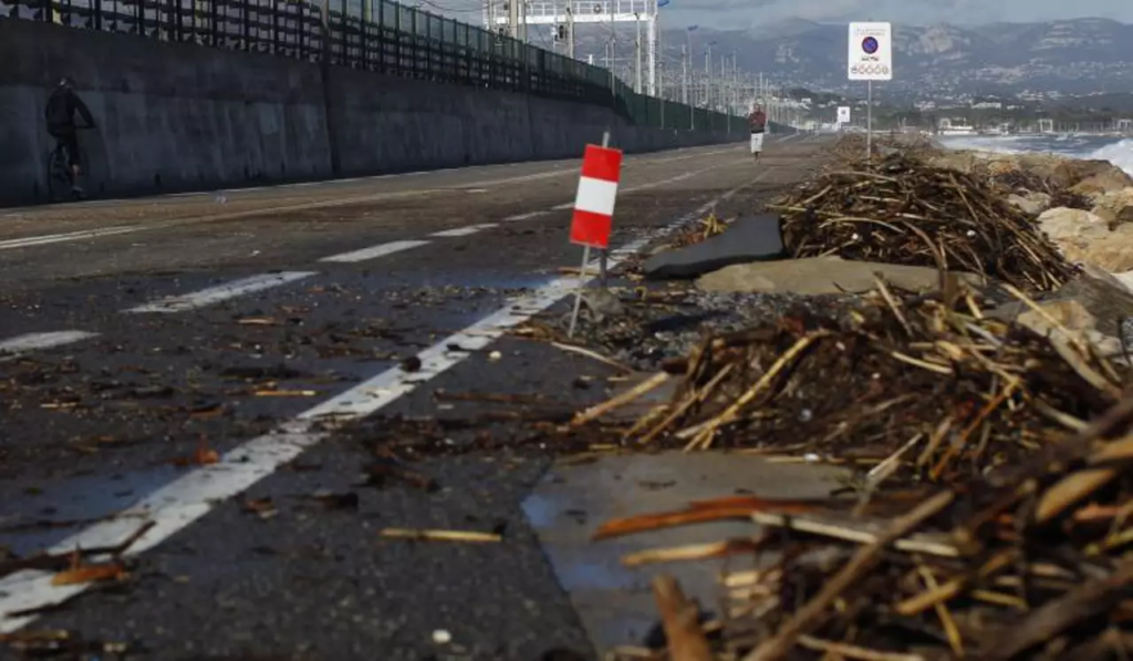
Nice Matin – © Photo Laurent Carré – Seafront road between Villeneuve-Loubet and Antibes closed to traffic due to heavy seas causing major delays
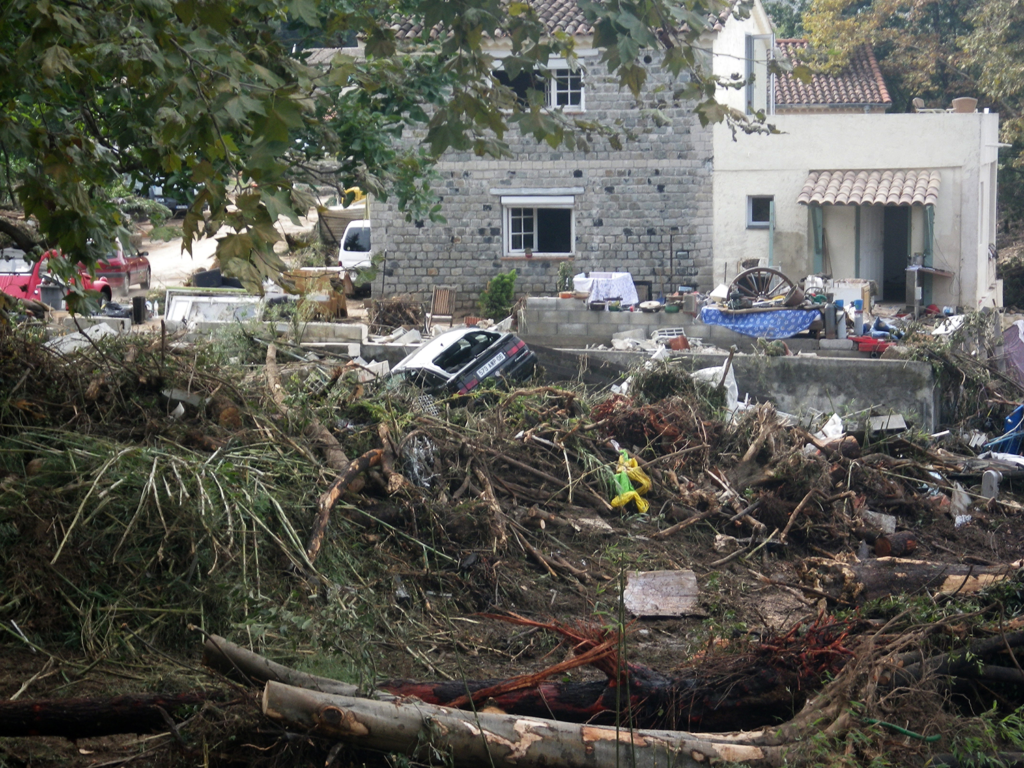
A huge logjam on the Brague at Biot following the floods of October 2015 © Photo DREAL PACA.
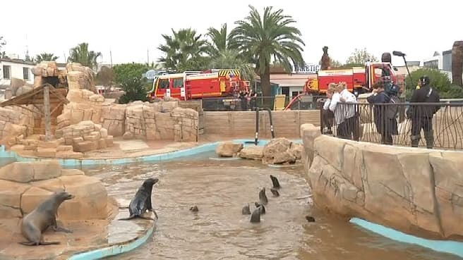
Marineland park clean-up operation following the floods of October 2015 © Photo BFM TV
Documents
CASadapt territorial diagnostic summary (narrative cartography) : https://drive.google.com/file/d/1X1S0JP4lI-9JVQeTPguy3ahfsKH8byd2/view?usp=sharing
4 prospective scenarios for tourism: https://librairie.ademe.fr/recherche-et-innovation/6703-quatre-scenarios-pour-le-tourisme-cotier-en-region-provence-alpes-cote-d-azur-a-l-echeance-2050.html