Geographic context and climate challenges
The promenades on the Catalan coast with the greatest risk of scouring or overtopping are in the Maresme and in some sections of the Garraf, the Tarragonès and the Baix Ebre stretches. Also, the ports of the northern half of the coast are more exposed to the loss of operability and to the flooding of the docks and piers due to the rise of the sea level, as a result of climate change.
These are some of the conclusions of the study on the vulnerability of ports and promenades to climate change (Pla d’adaptació al canvi climatic dels ports de Catalunya, 2023, Pla d’adaptació als impactes del canvi climàtic per a un conjunt representatiu de passeigs marítims de la costa Catalana, 2023). From the work on the 45 ports—all Catalan seaports, except those of Barcelona and Tarragona, which belong to the Autonomous Ports of the State—it is clear that the greatest risk they face is the loss of operability and, eventually, the flooding of docks and piers due to sea level rise. In the case of docks, the impact is somewhat less, given that in some ports there are floating pontoons that can be adapted relatively easily to this rise in level. The ports in the northern half of the Catalan coast are more exposed than those in the southern half, since, in general, the waves are more energetic in this area.
The analyzed ports are, in general, quite well prepared to face inoperability due to climate change in the 2050 horizon: 75% of the ports have zero, very low or low risk. Conversely, in the year 2100, 91% will present a high or very high risk of inoperability at their docks, associated with a low freeboard. Another risk detected is wave agitation. Between 16% and 25% are at high or very high risk of excessive agitation, depending on the scenario considered. This is particularly relevant in the northern area ports, where there are high risks of significant overtopping of the outer dikes by waves. In all ports on the Catalan coast, the risk is between 23% and 34%. Regarding the stability of these dikes, between 41% and 54% of ports have a high or very high risk of instability in some dike, depending on the scenario and horizon.
The risks of erosion and flooding have been calculated at 31 representative promenades distributed along the Catalan coast, considering future climate, the rise of the average sea level and the geographical location of the analyzed promenades. In addition to ports and promenades, the risks were calculated for 54 Catalan beaches. The results particularly highlight the increased risk in coastal areas of the three Catalan deltas (Ebre, Llobregat and Tordera). Rivers and streams act as preferential vectors of channelization with the consequent flooding of neighbouring low elevations. Of the beaches analyzed, around 35% will be affected, both temporary and permanent, by flooding under extreme sea level conditions and return periods of the order of hundreds of years.
In the same way, the most vulnerable beaches are those that have an elevation of less than 2 meters together with beaches that have emerged widths of less than 15 meters. If there are also promenade-type infrastructures or similar, these will have a high risk of scouring. In the case of both urban beaches and beaches under erosive retreat, the results show that the impact from flooding in storms will be high, as they do not have enough capacity for resilience, since the dynamic evolution of the sand body is hindered.
Objectives
The study points out measures for adaptation to climate change in 45 ports and 31 promenades representative of the Catalan coast. The study details the adaptation measures that would be needed, depending on the levels of risk detected, for each port and port facility and for each climate scenario and horizon. For each case and each port, a specific engineering project would be required which, in addition, addressed the mandatory environmental impact study. The technical means needed to carry out the adaptation measures already exist, as they all fall within the common practice of coastal engineering or port engineering. There is no need for exceptional measures, as the risks detected are already present in many port facilities around the world.
To carry it out, the work will be structured around the same general objectives as in the first phase and which are the following:
- Define the climate scenarios and time horizons that will be adopted in the study. This one combination of scenarios and horizons must correspond to plausible situations and representative of as wide a range of conditions as possible. On the other hand, the number it will have to be limited, given the large volume of work associated with the study of each case (combination of stage-horizon).
- Gather all the necessary information about the ports to be studied, to determine the degree of exposure and level of vulnerability. The indispensable information includes the bathymetry, the topography and plan of the port, the sections of the dykes, the elevations of the docks and jetties, the characteristics of the adjacent coasts, the type of jetties (fixed or floating) and the uses of the port, which will make it possible to determine the operational thresholds of the different works berthing.
- Select the oceanographic data (surge, sea level rise, tides, astronomical and meteorological) that will be used in the study. This data will be used to determine the levels of hazard associated with each climate scenario, based on its return period or its probability of occurrence.
- Carry out an average and extreme climate study of the swell for the scenarios and horizons selected. The extreme climate study will be used to analyze stability and overshoot by the swell of the seawalls. The average climate will be used to study the agitation processes port and landing of the ports.
- Propagate, from the high seas to the vicinity of each port, all the waves necessary to be able to calculate the different impacts of climate change.
- Estimate, for each scenario-horizon and for each level of danger considered, the impacts associated with each of the processes to be studied: inoperability or flooding of the docks and wharves, landing of the port, agitation in the docks, stability of the shelter dikes and overtopping by the swell of the seawalls.
- Define, in each port, for each process analyzed and for each scenario-horizon, a risk scale. Once all the risk values have been determined, their evolution based on the climate scenario and time horizon will be studied.
- Propose, for each port, the necessary adaptation measures to avoid or limit the detected risks as much as possible.
- Draw general conclusions about how climate change will affect Catalonia’s ports during the 21st century.
Both the diagnosis of the ports and the measures have been integrated into the corresponding sectoral planning instrument, the Catalan Ports Plan. Of the 30 million euros foreseen in the Ports Investment Plan for the period 2024-2027, 54% will be allocated to the fight against the climate emergency through the adaptation of infrastructure and the protection of ports, as well as measures to mitigate the ecological footprint.
Regarding the promenades, the general objective of the work was to analyze the potential effects of climate change on the functionality and stability of a representative group of promenades on the Catalan coast. These promenades have been chosen based on the following criteria:
- a) The frequency of resistant and functional damage on the promenades during the last years, according to the criteria of the appropriate departments of the Generalitat.
- b) That they are representative of the main orientations of the Catalan coast, given that it is one key factor in the wave effect on these promenades.
Adaptation measures implemented in the case
Adapting ports and promenades to climate change – sectoral planning
Solutions
Proposed adaptation measures were summarized in the report ‘Pla d’adaptació al canvi climatic dels ports de Catalunya’ (2023) for each port, each risk and each scenario. In some cases, the risk obtained is highly conditioned by the data used, which are based on model projections, which implies a high degree of uncertainty. That is why it is recommended that, before adopting a specific measure, a follow-up is carried out. Only proposals for adaptation measures are made at a general level. If necessary, for each port and each case, a specific project should be drawn up where the different possible alternatives should be analyzed and the obligatory environmental impact studies carried out. The measures are proposed by horizons and, within each horizon, by scenarios. There are several general adaptation measures presented that can be taken for each risk.
- Risk of inoperability of docks
In this case, the only effective measure is the elevation of the level of the docks. This can be done using directly concrete or by executing a filling (it can be of various materials), on which it is build the pavement using a concrete slab or a layer of asphaltic materials. In the case of docks that are inoperative due to reduction of the freeboard, the most sustainable measure is its replacement by floating docks, as these can be easily adapted to sea level variations associated with climate change.
There is a wide variety of types and materials on the market, in addition to anchoring and flotation systems, so in each case, the ones that are most convenient can be chosen. As an alternative to floating docks, fixed docks can also be used that allow regrowth and adapt to sea level rise. These measures are suitable for cases where the structure is not subjected to heavy loads, as is the case with fishing and recreational boats.
- Risk of dike instability
It is difficult to assign a priori a solution to each port, given that there are multiple alternatives that will be more or less effective depending on the level of investment available. In many cases, to verify the suitability of the solution, it is necessary to use physical model tests.
The solution will also depend on whether it is a vertical dike or a sloping dike. In the case of vertical dikes, solutions that could be applied are: incorporation of a slope supported by a vertical dike, reinforcement of the bench for vertical dyke, increase in the sleeve (width) of the vertical dike, or combination of the solutions.
If it is a breakwater, the options are: increased weight of breakwater blocks, modification of the typology of the blocks, such as replacing breakwater blocks or parallelepiped blocks with acropods, tetrapods, etc., incorporation of an intermediate berm on the slope.
- Risk of overtopping the dyke
In the case of the risk of overtopping the dike, the measures to be taken will depend on whether it is possible to rebuild the dike or not. If rebuilding the dike is not acceptable, the possible options are: construction of a barriers, smooth the slope of the main mantle, construction of an intermediate berm, modification of an intermediate berm (crown-width), construction of a cushioning bowl, construction of a submerged tandem dyke, or combinations of the solutions. If it is acceptable to rebuild the dike, the options are: rebuilding of the crowning and the width of the coronation of the main mantle, construction or rebuilding of the crowning of the pop-up wall (more barriers), increase in height and width of the crowning berm, or combination of the options.
- Risk of port agitation
If there is a risk of excessive port agitation, the solution usually involves changes to the port layout, such as modification of the distribution of docks and quays, or extension of seawalls/harbour dike to reduce port turbulence.
- Risk of siltation
In case of port siltation, the adaptation measure will depend on its intensity and speed. If the port silts slowly, periodic dredging (once every several years) may be sufficient. Conversely, if the need for dredging is frequent, then measures must be taken to provide more durable solutions. Among them are: construction of retention breakwaters, stabilization of the beach which is the source of the sediments, construction of sediment traps, performing bypass or backpass.
After the general adaptation measures, specific adaptation measures are presented for each port.
Finally, ‘Pla d’adaptació als impactes del canvi climàtic per a un conjunt representatiu de passeigs marítims de la costa Catalana’ (2023) proposes a general methodology for calculating the level of risk of the seawalls built in the emerged area of a beach, while considering the impact of climate change. Considering the limitations of the method, the results must be interpreted more from a qualitative than quantitative perspective. The results should be interpreted according to the risk level codes from 0 to 5 for any of the problems discussed (typology, overtopping and undermining) and, depending on the results in the short term (SLR=0.00 m), in the medium term (SLR=0.18 and 0.25 m) and long term (SLR=0.47 and 0.88 m).
Leader of the initiative and key partners
The work was carried out by the International Center for Research on Coastal Resources (CIIRC) and the Maritime Engineering Laboratory (LIM) of the Universitat Politècnica de Catalunya – BarcelonaTech (UPC), in collaboration with the Meteorological Service of Catalonia, Ports of the Generalitat and the Catalan Climate Change Office, and prepared for the administration of Generalitat de Catalunya.
Stakeholder participation
Not relevant at this stage. This work is an expert work made up of the members of the CIIRC and the LIM/UPC. These institutions, together with the Departments of Climate Action, Food and Rural Agenda and Territory of the Generalitat of Catalonia, have organized, on March 7, 2024, the Conference on the adaptation of ports, beaches and promenades of the Catalan coast to climate change.
Success and limiting factors
The study showed that the ports of the northern half of the coast of Catalonia are more exposed to the loss of operability and to the flooding of the docks and piers due to the rise of the sea level, as a result of climate change, and pointed out measures for adaptation to climate change. This relevance of the report in the Catalan context is the key ingredient of the successful future adaptation of the ports and promenades. The funds received from the Department of Climate Action, Food and Rural Agenda from the Climate Fund show belief in the climate change impacts on the ports and promenades of Catalonia, as well as the commitment which the regional government shows to coastal adaptation.
Regarding promenades, risk analysis on seafront promenades and their seawalls will be integrated into the Master plan for the protection and management of the Catalan coast, which is currently being elaborated by the Government of Catalonia. Based on the concept of adaptation pathways, the Master plan will define a strategy to adapt all coastal stretches between ports to climate change. In such work, the study on promenade adaptation to climate change will be a fundamental piece.
A propos the ports, the Pla d’adaptació al canvi climatic dels ports de Catalunya, 2023, analyzes the vulnerability and possible needs of Catalan ports in the face of different climate change scenarios and temporary scenarios (2050 and 2100) proposing a set of measures in this regard. In this sense, the next steps to follow consist of unifying the two phases of the Plan into a single document, that is to say the document that integrates the 45 ports of the Generalitat de Catalunya, as a dynamic document under continuous review to make the concrete adaptation measures as part of the implementation of the rest of the actions provided for in the Pla de Ports Horitzó 2030 (Horizon 2030 Port Plan).
Costs and benefits
The report has been fully financed by the Department of Climate Action, Food and Rural Agenda, with 408,600 euros from the Climate Fund, which is largely funded by the tax on CO₂ emissions from combustion engine vehicles. In addition, of the 30 million euros foreseen in the Ports Investment Plan for the period 2024-2027, 54% will be allocated to the fight against the climate emergency through the adaptation of infrastructure and the protection of ports, as well as measures to mitigate the ecological footprint.
The adaptation of the ports to climate change will be progressive as the investment programs in the ports directly managed by the Ports de la Generalitat entity are implemented or the concessions in the ports of indirect management are renewed. To the extent that the Investment and Financing Plan for Ports of the Generalitat (PAIF 2024-2027) has begun implemented and since it is the first year in 2024, the details on the execution are not available, that is say, neither of the solutions implemented nor of the positive results related to adaptation to climate change. The PAIF can be consulted at the following link: https://ports.gencat.cat/wp-content/uploads/2024/02/Document-PAIF-2024-2027.pdf
As far as the investment in promenades managed by the Government of Catalonia are concerned, they will be prioritized in the already mentioned Master plan for the protection and management of the Catalan coast. Costs will depend on the nature of each project and the pre-existing level of risk to tackle. Based on current estimates, the cost of promenade reinforcing can be of the order of 5 million euros per kilometre while the cost of promenade deconstruction rises to almost 2 million euros per kilometre (not accounting for land restoration costs). Instead, low-risk promenades that only need minor maintenance may require investments of 0,5-0,7 million euros per kilometre.
The adapted ports and promenades to climate change are expected to bring societal benefits to the whole region, in terms of resilience and maintaining the marine trade and tourism businesses.
Implementation time and lifetime
The preparation of the adaptation plan took 9 months. Following the preparation of the report, the implementation of the adaptation measures in Catalan ports. The actions recommended are multiple and diverse, emergency in the short term, and structural in the medium and long term, with the reinforcement of structures, the creation of new ones, or changes in pavement and drainage, among others. The various adaptation measures in ports will be implemented as provided for in the port management and planning instruments, new port projects and concessional renewals and always considering the different risk situations.
The implementation of the adaptation measures in coastal promenades can take several years, depending on the level of emergency and on the complexity and scope of each project, since in the case of promenades some projects may need to act also on adjacent infrastructure and land pieces. The aforementioned report (‘Pla d’adaptació als impactes del canvi climàtic per a un conjunt representatiu de passeigs marítims de la costa Catalana’, 2023) does a comprehensive risk analysis and outlines some possible measures, but which specific measures are to be applied to each seafront promenade are yet to be decided. A broader analysis, considering the entire sediment cell dynamics and the surrounding land uses (current and expected) is required. Notwithstanding the actions that are already being carried out year after year, a general implementation calendar of adaptation measures regarding seafront promenades managed by the Government of Catalonia will be initially defined in the Master plan for the protection and management of the Catalan coast and will be reviewed periodically.
Keywords
Adaptation plan, climate change adaptation plan for the ports, adapting coastal promenades, Catalan coastline.
Contacts
Prof. Agustín Sánchez-Arcilla
Director Laboratori d’Enginyeria Marítima (LIM/UPC), Centre Internacional d’Investigació dels Recursos Costaners (CIIRC), UPC – BarcelonaTech – ETSECCPB
C/ Jordi Girona 1-3, Edifici D-1, Despatx 110, Campus Nord UPC, 08034 Barcelona (Spain)
Tel. +34 93 4016472; agustin.arcilla@upc.edu ; www.lim.cat
Albert Grases Pallerols
Coastal Protection and Management Plan coordinator, Coastal Management Service
Directorate General of Mountain and Coastal Policies – Government of Catalonia
Josep Tarradellas avenue, 2-6 | 08029 Barcelona | (+0034) 93 554 70 06
albertgrases@gencat.cat | territori.gencat.cat
Source for more detailed information
Pla d’adaptació al canvi climatic dels ports de Catalunya (2023): https://canviclimatic.gencat.cat/web/.content/02_OFICINA/publicacions/publicacions_de_canvi_climatic/Estudis_i_docs_adaptacio/Informe-complet_ports-fase-II.pdf
Gironella X., Sierra J.P., Corrado A., Gironella A., Florio M., Gónzález-Marco D., Sánchez-Arcilla A. (2023). Pla d’adaptació als impactes del canvi climàtic per a un conjunt representatiu de passeigs marítims de la costa Catalana. IT-CIIRC-10-2023. : https://canviclimatic.gencat.cat/web/.content/02_OFICINA/publicacions/publicacions_de_canvi_climatic/Estudis_i_docs_adaptacio/2-IT-CIIRC-10-2023-INFORME_fase-II.pdf
Financing Plan for Ports of the Generalitat (PAIF 2024-2027): https://ports.gencat.cat/wp-content/uploads/2024/02/Document-PAIF-2024-2027.pdf
Map
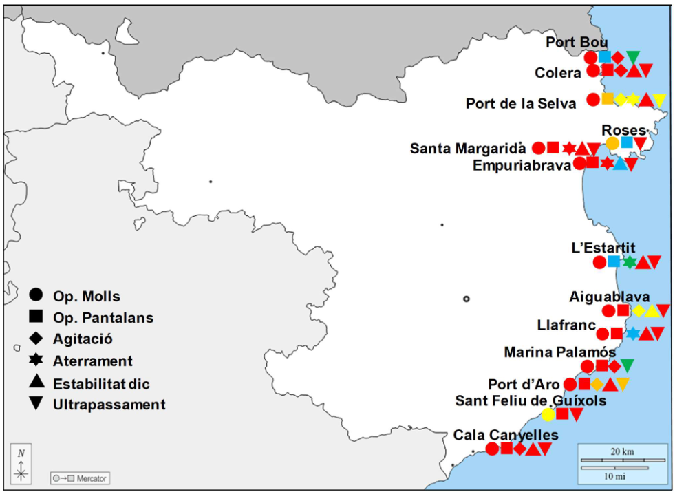
Map 1: Map of risks in the North Port Zone, RCP8.5 scenario and horizon 2100, with types of risks, from very low risk (green) to very high risk (red). ©Pla d’adaptació al canvi climatic dels ports de Catalunya (2023), page 307.
Pictures
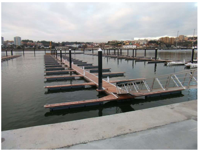
Figure 1: Example of a dock that can adapt to sea level rise. ©Pla d’adaptació al canvi climatic dels ports de Catalunya (2023), page 313.
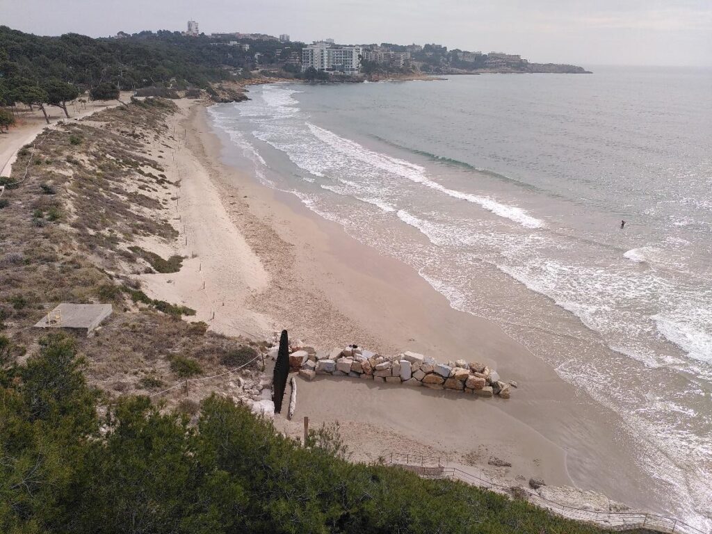
Figure 2: Example of a seafront promenade protected by a human-managed dune system in Salou (Tarragona). Catalan Government Coastal Management Service.