Geographic context and climate challenges
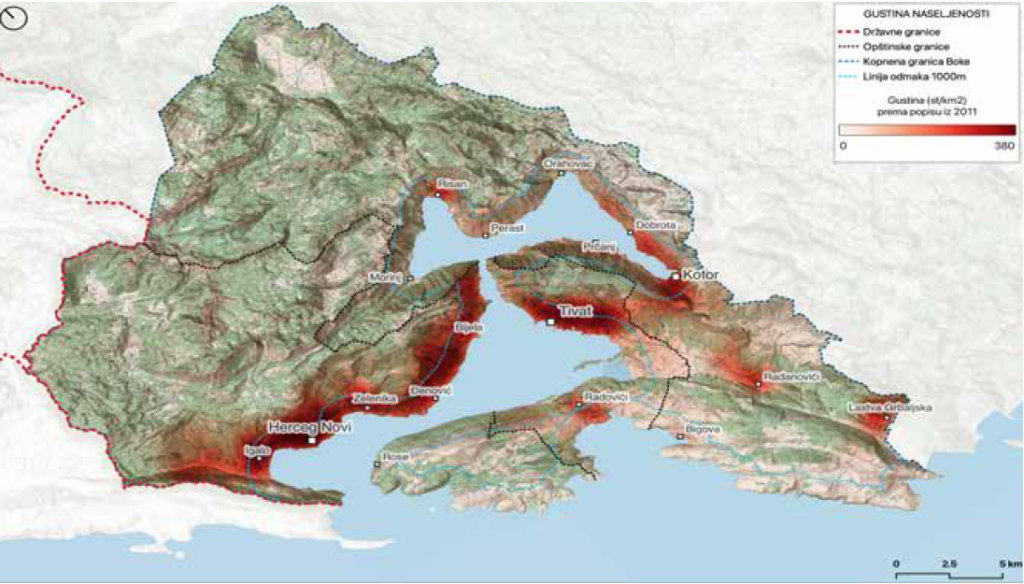
The Boka-Kotorska Bay is a unique part of the Adriatic Sea with its specific geomorphological, climatological, hydrological and biotic characteristics. The bay is extremely closed, surrounded by mountains Orjen and Lovćen that « fall » into the sea. In the area of Boka, there are numerous underwater sources such as Škurda, Široka rijeka, Ljuta, Gurdić, Sopot. In the interior of the Bay there are historical settlements with old palaces, churches, cathedrals, fortresses, and defensive walls, which resulted in the inclusion of the inner part of the Boka Kotor Bay (Kotor-Risan Bay) on UNESCO list of cultural and natural heritage of mankind, while Tivat and Herceg-Novi bays form a buffer zone. The Bay is also famous for the slopes of the Lovćen National Park, Tivatska solila (Tivat saline, on the Ramsar list), and on the sea are ecologically extremely valuable localities – Sopot and Dražin Vrt, declared protected areas in 2024.
After the earthquake in Boka in 1979, the construction of residential areas for collective housing, as well as individual residential buildings, stimulated by the needs of the local population and the development of tourism. This type of urbanization occupies not only the spaces between the buildings of traditional architecture in the coastal area, but also spreads to areas of untouched nature along the coastal belt and on the slope’s hills in the hinterland of the settlement. Migration pressure on the coast, i.e. population depletion of areas far from the coast, is characteristic in Montenegro. Also, within the municipalities in the coastal area, the emptying of settlements in the hinterland is noticeable and population growth in the urban centres of municipalities on the coast, which is reflected in the high population density along the coast of the bay. According to the preliminary results of the population census, from 2011 to 2023, in the municipalities of Boka, there was a disproportionate increase in the number of apartments in relation to the number of inhabitants. In the municipality of Herceg Novi, the number of inhabitants increased by about 2%, while the number of apartments increased by 24%, in the municipality of Kotor, the number of inhabitants decreased by about 3% and the number of apartments increased by about 26%, while in the municipality of Tivat, the population increased by about 16% followed by an increase in the number of apartments by 60%.
Along with tourism and coastal construction, waste and traffic solutions, an important topic for the future of Boka, especially if we look at it through the lens of climate change, is the issue of water resources. From an area rich in water in winter (Crkvice locality is one of the rainiest areas in Europe), in summer this area becomes poor in water, when water is most needed due to the additional influx of consumers – tourists. Climate change will bring an additional decrease in water availability in the summer, which is especially worrying when we consider that the yield of the regional source for water supply « Bolje sestre » is decreasing year by year. Water supply is made even more difficult by the current large losses in the water supply network.
Finally, the area of Boka Kotorska, in the last 40 years or so, has been characterized by an increase in temperature (which is more pronounced in summer), and a decrease in the total annual amount of precipitation, i.e. an increase in dry days. To this should be added extreme events such as flash floods, but also floods from the sea, which in combination with rising sea levels will further threaten the coastal area, especially localities such as the old town of Kotor, Igalo, Morinj, Tivat and others. The preparation of the Coastal Plan represents a new way of preparing for adaptation to the impacts of climate change in an integral way, and a contribution to the practice of spatial and development planning, not only in Boka-Kotorska Bay, but also in the whole of Montenegro.
Objectives
The objectives of the Coastal Management Plan for the Boka-Kotorska Bay are as follows:
- direct the management of the development of the coastal area of Boka-Kotorska Bay towards sustainability and strengthen resistance to climate change;
- to provide support for the formulation of sectoral policies, and their integration into policies for the sustainable development of the coastal area; and
- propose priority responses to the main pressures on the environment and the impacts of climate change.
The coastal management plans are not a « normative » (i.e. prescribed by law) plan, but belong to the group of « indicative » plans, i.e. plans that give guidelines on how to manage certain issues and define measures that should then be incorporated into normative plans. Based on previous experience, such plans can be useful as a basis for withdrawing financial resources for the implementation of defined measures, primarily from the European Union, but also from other donors.
The plan is primarily intended for decision-makers in three municipalities: Herceg Novi, Kotor and Tivat, stakeholders of (national) institutions and associations whose activities are in any way related to the coast, as well as everyone who lives in the coastal area of Boka-Kotorska Bay or is there for work activities, investments or leisure and recreation.
Adaptation measures implemented in the case
Adaptation through integrated coastal zone management plans and programmes.
Solutions
Management measures for tackling the key issues of the coastal area of Boka-Kotorska Bay are aimed at achieving balanced, sustainable development, as well as climate resilience of the coastal area. The measures are grouped by themes that were recognized as priorities by local and national actors during the preparation of the Plan.
In light of the impact of climate change, one of the priorities in the narrow coastal zone is the protection of the population and settlements on the coast, primarily from floods and erosion. One of the key measures to achieve this is the implementation and respect of the coastal setback. Namely, 100m from the coastline in areas outside the settlements in Montenegro, the construction of buildings is prohibited according to the criteria defined by the ‘Spatial plan of special purpose for the coastal area of Montenegro’ (2018). Respecting the implementation of the coastal setback reduces the number of new properties, which are vulnerable to floods and erosion, in addition to the coastal line. Setback also contributes to the preservation of biodiversity and creates the potential for new habitats, and increases the possibility of developing tourist projects of a higher standard, which require such a step for the arrangement of public, green, recreational, and beach facilities.
In order to fight against coastal erosion, it is important to preserve coastal forests and natural beaches in the narrow coastal zone, to encourage the natural renewal of forests and indigenous vegetation, and to reforest where necessary. Some beaches that are subject to erosion need to be replenished with sediment, but this can have a negative impact on the living world in the coastal zone, including commercial species. To reduce this impact, it is necessary to develop a formal procedure and guidelines for replenishing the beaches in the Boka-Kotorska Bay. One of the options is the creation of an alternative beach space – floating surfaces, i.e. smaller pontoon bathing areas of a demountable nature, which are considered to have a less harmful impact on the environment than replenishing beaches. In the most vulnerable zones of the coastal area, one should also think about protective structures (e.g. small seawalls or detached breakwaters) that would prevent major floods on the coast itself.
In the hinterland of Boka, future (re)construction should be linked to existing traditional settlements or to the activities of agricultural farms and processing of characteristic agricultural products (olives, citrus fruits, coastal crops). In this way, agricultural production is combined with tourist offer (agritourism) and different forms of outdoor recreation. In the hinterland, it is important to preserve forests and other vegetation, and reforest low-productivity degraded areas surface, which helps mitigate rapid water runoff as well as preventing significant erosion effects. It is necessary to implement and other preventive measures to prevent floods, such as cleaning flood channels. Green areas should be preserved and created throughout urban areas. They cool the air by shading and increased evaporation of water, and thus reduce the occurrence of health problems of the population caused by the heat, but also reduce cooling costs in summer. The ability of green infrastructure (Nature-based Solutions – NbS) to retain and absorb water into the ground is an important property for preventing urban flooding and can reduce torrential flows, while the roots stabilize the soil and thus reduce erosion.
Apart from the aforementioned heat, flooding and erosion, a problem that could worsen with climate change in Boka-Kotorska Bay is the spread of fires due to the increase in dry days. Therefore, fire prevention measures are important, such as cleaning dry vegetation and waste from the forest floor, establishing fire corridors, etc. It is also necessary to plant protective vegetation – olive groves, vineyards, orchards, etc., hydrant network, retention, early warning system – setting up a camera surveillance system for early fire detection. Measures to rehabilitate burned areas by formation are also important of new forest or agricultural areas, but also a ban on building on burned areas.
In addition to these measures related to climate change adaptation, the additional measures were proposed for the other priorities of the Coastal Management Plan: transport system, water management, waste management, marine environment and pollution, and sustainable tourism.
Leader of the initiative and key partners
The creator of the Coastal Management Plan is the Priority Actions Programme/Regional Activity Centre for coastal management (PAP/RAC) from Split, Croatia, in cooperation with the Montenegrin Ministry of Tourism, Ecology, Sustainable Development and Development of the North, and with Plan Bleu/Regional Activity Centre from Marseille, France, which led the participatory « Climagine » workshops, in which many local and national actors participated.
Stakeholder participation
An integral part of the creation of the Coastal Management Plan was implementing a participatory method “Climagine”. “Climagine” aims to identify and review the past, present and future levels of sustainability of the project area. Through four workshops, held in all municipalities surrounding Boka bay, up to 50 local and national actors per workshop discussed the critical issues of the coastal development of Boka-Kotorska Bay, and jointly sought solutions to achieve the sustainability and resilience of the coastal area. At the initial workshop in Tivat in December 2021, the priority topics that the Plan will deal with were determined: space and traffic; water; waste; sustainable tourism and marine environment. The advantage of the integral approach is that through a participation the priority topics are determined, i.e. those topics that represent the greatest challenges for sustainable development. Climate change is recognized as a topic that affects, to a greater or lesser extent, all the other recognized topics listed above. Among stakeholders that participated on the workshops and contributed to the development of the Plan were members of different Ministries (apart from Ministry of Environment, also Ministry for Spatial Planning, Ministry of Agriculture, Forestry and Water Management), departments for environment and/or spatial development from municipalities Herceg Novi, Tivat and Kotor, Institutions – Institute of Hydrometeorology and Seismology of Montenegro, Institute of Marine Biology, Public Enterprise for Coastal Zone Management of Montenegro (JP Morsko dobro), and several NGOs.
Success and limiting factors
The success of the Coastal Management Plan will be determined by the political will in Montenegro to work towards sustainable development of the whole Montenegrin territory, and to develop strategic planning as a preparatory activity of the Montenegrin process of joining the European Union and its funding schemes. Discussions at participative workshops that followed the stages of the development of the Plan of Boka-Kotorska Bay and the main results of those discussions were included in the Plan itself, which highlights the high participatory nature of Plan preparation. After defining the priority topics at the initial Climagine workshop, local and national experts were engaged who contributed to the creation of the Plan, while the creation itself was coordinated by PAP/RAC. Local experts contribute to the success of the plan due to their knowledge of the area and contacts across the entire scientific, administrative and business community of Montenegro.
The plan was created following the planning stages proposed by the Integral Coastal Zone Management process (ICZM process), which consists of five basic planning phases: introductory activities – establishment; analysis of the situation, definition of the vision, design of the future and realizing the vision. Finally, during the preparation of the Plan, interviews were conducted with actors at the local and national level, and the results of these interviews were included into the Plan itself, which additionally contributed to a deeper analysis and inclusion of the concerns of local actors in the Coastal Management Plan.
Finally, several limiting factors can be listed that might hinder the process: lack of implementation system, lack of horizontal integration, especially between municipalities, lack of clarity about who is responsible for what, lack of funds and personnel to deal with implementation.
Costs and benefits
The preparation of the coastal plans is one of the most demanding activity of the GEF MedProgramme at PAP/RAC, with four staff members involved with different tasks and allocations in four different countries, Montenegro being one of them. In addition, the technical resources for the Coastal Management Plan of the Boka-Kotorska Bay consisted of an expert team led by PAP/RAC and composed of a national team leader and five local and national experts covering the priority topics of the Plan, and a GIS specialist.
As for the financial resources, the GEF MedProgramme, both CP2.1 and SCCF projects, support was of cca USD100,000. The administration of the three municipalities (Kotor, Tivat, Herceg Novi) and the Montenegrin Ministry of Tourism, Ecology, Sustainable Development and Development of the North and PAP/RAC provided co-financing in-kind through the work of their human/technical resources, together with kind contribution of all stakeholders that provided comments through different stages of Plana development. The Coastal Management Plan benefited from the parallel activities by Plan Bleu/RAC implemented with separate financing but within the same project GEF MedProgramme.
Regarding benefits, the Coastal Management Plan – as a strategic document in the field of planning – gives the future vision for the coastal parts of the Boka-Kotorska Bay and serves as a reference for all the sectoral documents that will have to take into consideration the Coastal Management Plan. At the heart of the ICZM approach adopted is the need to reconcile and integrate sectoral policies at the regional level.
Implementation time and lifetime
The Coastal Management Plan of the Boka-Kotorska Bay is envisaged by the National ICZM Strategy for Montenegro, which was adopted by the Government of Montenegro in 2015. Preparation of the Plan was initiated in late 2021 and finalized in the end of 2024. It is intended as a “living document” meaning that there is no specific implementation deadline, but it will be revised and updated from time to time. Since the Plan is integrated in its nature, different Plan measures have different priorities, and hence, different implementation “deadlines”.
Keywords
coastal management plan, coastal protection, ICZM, land-use planning, local governments, sustainable development, stakeholder engagement.
Contacts
- Milica Rudić
Ministry of Tourism, Ecology, Sustainable Development and Northern Region Development, Government of Montenegro
Email: milica.rudic@mert.gov.me
Webpage: https://www.gov.me/en/mert
- Ivan Sekovski, Programme Officer at UN Environment Programme / Mediterranean Action Plan – Priority Actions Programme Regional Activity Centre (PAP/RAC), Split, CROATIA
Email: ivan.sekovski@paprac.org ; http://www.paprac.org
Source for more detailed information
https://gefmed.paprac.org/
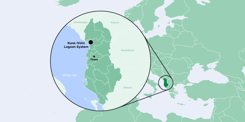
Map
Pictures
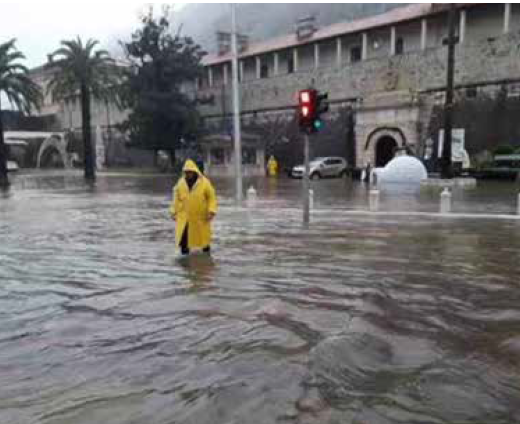
Figure 1: Flood in the old town of Kotor (bokanews.me)
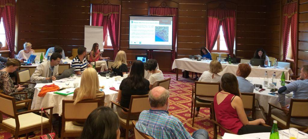
Figure 2: Four participatory meetings of the coastal management plan were prepared in three municipalities of the Boka-Kotorska Bay.
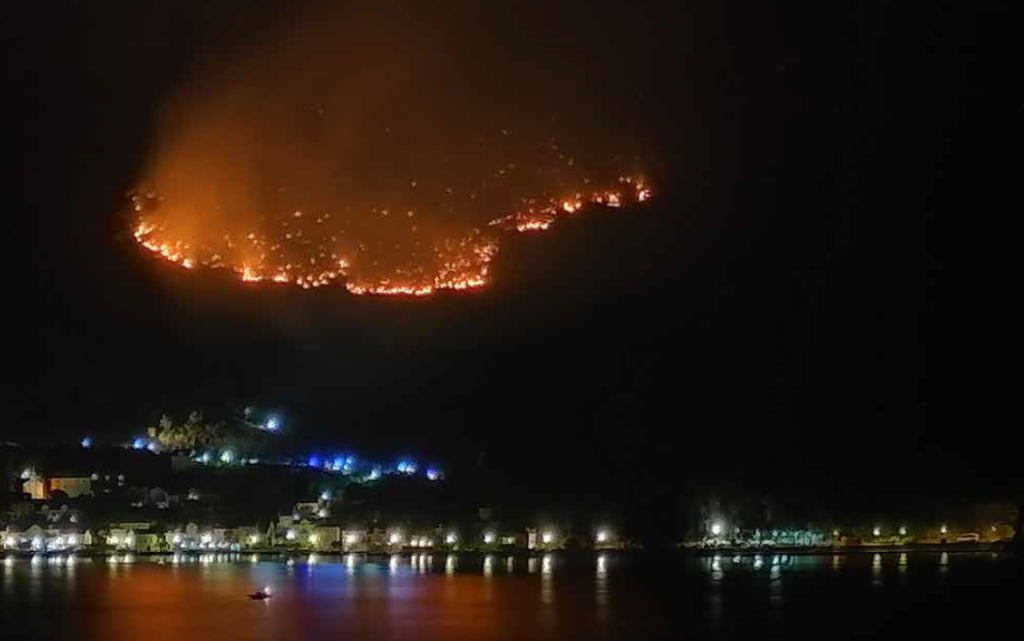
Figure 3: Wildfire above the town of Perast (bokanews.me)