Geographic context and climate challenges
This project aims to reduce the risks of coastal flooding in the North Coast and the Nile River Delta region of Egypt, especially in the five most vulnerable and endangered hotspots within the Nile Delta with a length of 69 km, which were identified during the engineering scoping study and the technical feasibility study, and it is also working on developing a plan Integrated coastal zone management (ICZM) for the entire northern coast to manage the risks of climate change in the long term, and to provide Egypt with the ability to adapt to the imminent flood risks.
IPCC has singled out low-lying river deltas to be one of the most vulnerable systems in the world to climate change and sea level rise. They are home to millions of people, highly productive agricultural lands, industrial/transport infrastructure and valuable touristic assets. For the Nile Delta, the problem is aggravated by the compound effect of sediment consolidation (i.e., compaction of river sediments over time) leading to natural lowering of delta areas in addition to anthropogenic factors (groundwater abstraction, construction of upstream dams which restrict the flow of sediment that would otherwise reach the river mouth and build up delta lands). The Nile Delta is classified in the IPCC Fourth Assessment Report as one of the world’s three “extreme” vulnerable hotspots under climate change. The rate of sea level rise for the Nile Delta ranges between 3.2 – 6.6 mm per year. The IPCC concludes that global mean sea levels have risen between 2.8 and 3.6 mm per year over the period 1993 to 2010. During that same period, local land subsidence has been evident across the entire Delta, with actual rates ranging from about 0.4 mm/year in Alexandria to the West to around 3.0 mm/year in Port Said to the East.
The Nile Delta accounts for more than 50% of the country’s economic activity through agriculture, industry and fisheries, contributing about 20% of the country’s GDP and accounting for the employment of 30% of the national labor force. As Egypt is far below food self-sufficiency, any loss of prime agricultural land due to coastal flooding will have a direct adverse impact on the livelihoods of millions of people and lead to hardship throughout the entire economy. Extreme storm events, driven by the combination of high tides associated with sea level rise and storm surges, have led to devastating coastal flooding and millions of dollars in damages (for example the flooding events in Alexandria 2015).
Moreover, coastal areas in the Nile Delta will be vulnerable to an increasing frequency and intensity of extreme coastal storms associated with sea level rise. With a considerable level of uncertainty in climate modeling efforts, regional projections at the spatial scale of the Nile Delta are even more difficult, as they need to account for both storm intensity and changes in storm tracks. Nevertheless, Southern Mediterranean has already seen a measurable increase in the number of natural disasters: from an average of three natural disasters per year in 1980, to more than 15 per year in 2006. An increase in frequency and severity of storm surges is already evident over the past seven years, with three extreme storms most commonly associated with 1-in-50-year storm events. Thus, despite its relatively negligible contributions to global greenhouse gas emissions, Egypt is disproportionately burdened with the need to cope with climate change risks.
Studies on the vulnerability of Alexandria indicated that sea level rise of 0.3 meters would lead to infrastructure damage worth billions of dollars, displacement of over half a million inhabitants, and a loss of about 70,000 jobs (El Raey, 2004). Moreover, the Nile Delta’s coastal lagoons are among the most productive natural systems in Egypt and they are internationally renowned for their abundant bird life. Approximately 60% of Egypt’s annual fish catch are from three main Delta lagoons, Idku, Burullus and Manzalla, separated from the Mediterranean by a mere 0.5- 3 km sand belt and dune system. Coastal flooding and/or permanent inundation of these areas would lead to a decline in water quality adverse impacts on fishery activities. Potential impacts of climate change in Egypt estimated a reduction of 16% in agricultural production by 2030 and up to 47% by 2060, with reductions in agriculture-related employment of up to 39% leading to millions of people losing their jobs. Welfare losses in agriculture in 2060 are estimated to range from 4.5 to 26.5 billion USD. Food prices could increase by 16 to 68% further threatening food security in the country. Climate change induced sea level rise also threatens critical infrastructure for the Egyptian economy and trade such as roads and ports. Loss of beaches, and higher temperatures affecting coastal ecosystems could reduce annual tourist revenues by 10 to 12 billion USD.
Objectives
All these factors make the low-lying North Coast and Nile Delta region a high priority for adaptation to climate change in Egypt. Such concerns are well-reflected in Egypt’s National Communications (Government of Egypt 1999, 2010, 2016) under the United Nations Framework Convention on Climate Change (UNFCCC). The Sustainable Development Strategy 2030 also includes coastal adaptation to climate change and investment in infrastructure to face climate change is priority. The Government has already started addressing these urgent needs for Alexandria, committing $200 million to constructing hard coastal protection structures there, while seeking to develop an ICZM approach to the long-term planning for the entire North Coast in the face of climate change. One of the most prominent obstacles to ICZM in Egypt is the complex and sometimes unclear institutional framework for addressing development activities, as well as the limited, ad hoc cooperation among different agencies. Nonetheless, there have been some developments in Egypt that have advanced strategies and plans that are compatible with an ICZM framework and can be leveraged in the project, and that could contribute to Egypt’s ratification and implementation of the Mediterranean Action Plan’s Protocol on the Integrated Management of Mediterranean Coastal Zones developed by Barcelona Convention and signed in 2008.
This project seeks to support adaptation efforts of Egypt in the Nile Delta which is identified by the IPCC in its Fourth Assessment Report as one of the world’s three “extreme” vulnerable hotspots. The main objective of the project is to reduce coastal flooding risks in Egypt’s North Coast due to the combination of projected sea level rise and more frequent and intense extreme storm events.
Output 1 focuses on constructing 69 km of sand dune dikes along five vulnerable hotspots within the Nile Delta that were identified during an engineering scoping assessment and technical feasibility study. Output 2 focuses on the development of an ICZM plan for the entire North Coast, to manage long-term climate change risks and provide Egypt with adaptability to impending flood risks.
The barriers addressed by the project include lack of high-quality data to inform planning decisions; absence of a suitable framework for implementing integrated approaches to coastal adaptation; weak institutional coordination to build coastline resilience to sea level rise impacts; and low institutional capacity to anticipate and manage expected sea level rise impacts. The project facilitates transformational change in in the short-term by reducing coastal flooding threats along vulnerable hotspots in the Delta and in the long- term by integrating additional risks of climate change into coastal management and planning, budgeting and implementation of risk reduction measures.
Adaptation measures implemented in the case
Adaptation through integrated coastal zone management plans and programmes
Construction of sand dune dikes
Solutions
The project aims to enhance the resilience of local communities in the Northern coast and Nile Delta in Egypt, through integrated coastal management and scaling up the use of soft engineering solutions and ecosystem-based adaptation measures. Such measures would curtail negative potential impacts including displacement of local coastal communities, businesses, young people and women. This project provides adaptive measures to cope with climate related impacts in the Delta’s most vulnerable areas located across 69 km in five areas. Concurrently, the project also addresses the broader and longer-term climate change adaptation challenges seeking an integrated coastal development plan for Delta and the entire North Coast. The challenges addressed by the proposed project are high priorities in Egypt’s national strategy for adaptation to climate change and will address baseline vulnerability conditions, build upon past coastal protection interventions and leverage recent coastal adaptation initiatives.
The Climate Adaptation Enhancement Project aims to protect 69 km in the coastal areas most affected and exposed to submersion, within the five governorates of Beheira, Kafr El-Sheikh, Dakahlia, Damietta and Port Said, from West to the East side of the Delta.
- The shore protection works in Beheira Governorate protects citizens within a 6.5 km range, starting from the west of the mouth of the Rosetta Branch to the Petroleum Company and north of the new Rosetta city, in one of the low-lying areas that are at risk of inundation as a result of rising sea levels due to climate changes. It also protects investments such as (New Rosetta City, agricultural lands and Rosetta National University) It is estimated at about 1.5 billion pounds, and the project will benefit from the protection bridge as a walkway for vacationers.
- The shoreline project in Kafr El-Sheikh protects citizens from the dangers of submersion and sea level rise due to climate changes in the length of 29 km, starting from the west of the fishing port in Borollos to the mouth of the Rashid branch. It also protects investments of about 1.194 billion pounds (Borollos powerstation – the industrial city – a water station Drinking – Coastal International Road).
- Enhancing climate adaptation in Dakahlia Governorate will be within a range of 11,6 km to protect citizens. The protection will start from the western entrance to the city of Gamasa until the end of the New Mansoura City from the west. The project that will protect investments is estimated at about 96 billion pounds (Gamsa, Sheikh Zayed and New Mansoura cities – Delta University and New Mansoura University – the international coastal road). The protection consists of raising the levels of the beach area in front of the Corniche with coarse sand supplied from quarries to a level of (2.00+).
- The project enhancing climate adaptation in Damietta Governorate starts with the protection zone from the eastern entrance to the city of Gamasa (in Dakahlia) to Damietta, within a range of 10,6 km. It protects citizens and investments estimated at about 96 billion pounds, including the New Damietta City, tourist facilities, and the international coastal road.
- The climate adaptation in Port Said includes a protection zone within a range of 11 km. It protects citizens and investments estimated at about 275 million pounds, including the Belaim Petroleum Company, the International Company for Pipes, the Pharaonic Petroleum Company, fish farming project, Al-Diba and Al-Jaraba villages, tourist facilities and the international coastal road.
In addition, the climate adaptation project aims not only at sustainable development and protecting the coastal areas and their citizens from climate changes over the coming decades, but also targets the social dimension of the current citizens by raising their standard of living. It cooperates with some civil society organizations and research centers in presenting small and experimental projects. The nine proposals for community development activities had to be seen in a wider framework, following the vision: “To support coastal communities to become more resilient to coastal flooding and expected sea level rise”. The proposals were elaborated by Abdrabo and Hassaan (2020):
- provision of good quality drinking water using solar powered water purification units,
- improving market access for handicraft products made by local women,
- development of women capacity building program,
- landscaping of proposed protection work,
- developing integrated municipal solid waste management system,
- developing a solid waste management system for compositing,
- provision of sanitary sewer systems,
- establishment of a fish processing plant,
- supporting sustainable mode of local mobility.
Finally, although in the near-term coastal protection is urgently needed for five hot spots identified as areas that are the most highly vulnerable to climate change, ICZM that incorporates capacity building and accounts for all stakeholder perspectives is needed in the longer-term to establish a basis to address future sustainable development activities along the North Coast. Output 2 of the project is Development of an ICZM plan for the entire North Coast of Egypt, which is expected to be adopted by the end of the project (December 2025).
Leader of the initiative and key partners
The project was agreed between the United Nations Development Programme (UNDP) and the Arab republic of Egypt, and signed on 11th December 2018 by Randa Aboul-Hosn, UNDP Representative in Egypt, with the award ID 00098798, for a duration January 2019 – December 2025.
Egyptian Ministry of Water Resources and Irrigation (MWRI) is the National Executing Partner (Implementing Partner of UNDP) and provides project management support and parallel/in-kind contribution to project implementation through its technical and administrative staff and systems. The Shore Protection Authority (SPA) that falls directly under the MWRI is responsible for protection of the Egyptian coasts along the Mediterranean and Red Sea. SPA is responsible for managing the shoreline in coastal areas that have socioeconomic value or natural resource value that are threatened by erosion. SPA develops coastal zone management plans, designs projects for shore protection, and issues license for projects located in the coastal zone area. It is a key player in the implementation of project activities because of its experience in coastal protection structures and planning activities in the North Coast.
The National Water Research Center (NWRC) is the research executive arm for the MWRI. In particular Coastal Research Institute (CoRI) is responsible for investigating the coastal process along the Nile Delta as well as all the entire Egyptian coasts; monitor the evolution of the Egyptian coast, study the dynamics of its shores and to find out efficient and cost-effective control methods to protect valuable coastal infrastructure from erosion. It works closely with SPA on diagnosing coastal threats and has been at the forefront of calls for urgently protecting areas under threat from sea level rise-induced flooding and for the development of an ICZM plan to guide future development plans along the North Coast.
MWRI including SPA & CoRI have sufficient institutional capacities to perform all related tasks and technical expertise from universities is also sought when needed. International technical expertise is needed for the modelling of the ICZM plan in collaboration with the Egyptian counterparts. Egyptian Environment Affairs Agency (EEAA) hosts the ICZM national focal point for all environmental issues and oversees strategic directives related to compliance with national and international environmental norms.
Stakeholder participation
The project is informed by the several rounds of discussions with stakeholders at the national and local levels on climate change adaptation options and priorities in the Nile Delta. The project built on past and ongoing stakeholder consultations regarding the overall protection of the North Coast of Egypt from flooding and other threats. It has involved engagement, typically as part of consultative workshops, of representatives from MWRI, SPA, CoRI, other governmental agencies, UNDP, and representatives from local businesses and communities. In all, the project was designed based on the input generated from a total of 36 related stakeholder consultative workshops held over the period 2015-2016. On a consultative workshop organized on 17 August 2016 in Cairo, the emerging project design was presented to stakeholders from SPA, CoRI, EEAA, General Organization for Physical Planning, National Center for Planning State Land Uses, Tourism Development Authority and Coastal Governorates.
In joint collaboration with EEAA, the preparation of the ICZM Plan involves all coastal stakeholders in an effort to build awareness of the value of coastal resources and create a sense of ownership, contributing to its involvement in long term shared goals. ICZM initiatives have development mechanism that promotes stakeholder awareness and participation through the organization of workshops, hearings, and launching an ICZM website and a geo viewer. These will be leverage by the project to develop the regulatory framework for a comprehensive Coastal Management Plan. A preliminary list of stakeholders includes those related to fishing (fishermen community, fish farms, National Company for Fish Farming, General Authority for Fisheries Resources Development), bird poachers, farmers, resorts and recreational beaches, urban areas near the sea, industrial areas, power plant, NGOs, environment and surface, scientific communities and coast guards, from five different areas of the project (Governorates of Port Said, Damietta, Dakahlia, Kafr Al Sheikh, and Beheira).
Success and limiting factors
The project is expected to reduce vulnerability to sea level rise. Green Climate Fund funding will be directed to overcoming a number of key barriers such as lack of high-quality data to inform planning decisions, and lack of a suitable framework for implementing integrated approaches to coastal adaptation. The project strengthens national capacities to adapt coastal zones with climate change impacts first in the hotspot sites and then scaled up within an ICZM process, while adding on to what has already been accomplished through a “paradigm shifting” approach. Key lessons and success factors have been drawn from previous major Government initiatives (such as enhancing Mohamed Ali sea wall and installing protection works for the low-lying area of El Malaha East of Port Said) and incorporated into this project. It demonstrates the effectiveness of soft protection measures in the Nile Delta; it promotes launching ICZM processes in Egypt; and facilitates stakeholder engagement mechanisms for promoting inter-agency coordination on coastal management issues.
Until now there is lack of a holistic approach to climate change mitigation and adaptation planning. Addressing climate change vulnerability and adaptation efforts in Egypt to date has been focused on specific sectors, particularly agriculture, water resources and coastal zones. Some regions, particularly north coast and the Delta “Mediterranean Region”, have received more funding attention than other regions, because of the threat of sea level rise, and the fact that these areas have been hit by extreme weather events (therefore having visible vulnerability). This means that to date most vulnerability assessments and adaptation studies have been conducted for these regions. However, recorded damage and economic losses due to extreme weather events throughout the country have revealed the weaknesses of local authorities in handling climate change impacts and the need to address extreme weather events, exacerbated by climate change, in a more comprehensive manner country wide. There remains a lack of government capacity, weak response efforts, and limited early warning systems infrastructure in many areas. For these reasons, and for scaling up climate ambition on land use and agriculture (SCALA) through nationally determined contribution and national adaptation plan, UNDP and FAO (Food and Agriculture Organization of the United Nations) are supporting a project SCALA, jointly supported by German International Climate Initiative. All of these initiatives show the Egypt’s dedication to adapt and mitigate the impacts of climate change and jointly contribute to success of climate change adaptation efforts in Egypt.
Costs and benefits
The main donors are UNDP and Green Climate Fund, with total budget administered by UNDP of $31,484,800. The project profits of parallel co-financing by the Egyptian Government at the amount of $73,707,000, which gives a grand-total project financing of $105,191,800.
The project estimates that nearly 0.75 million inhabitants will directly benefit from the soft interventions involved, almost half of which are women. The total direct and indirect beneficiaries of the project reach about 17 million inhabitants and represent about 18% of the Egyptian population (female: 49%; male: 51%). As for the second output of the project (development of an ICZM plan), it is expected to produce far more outreach in the long term. Various benefits of ICZM are improved decision-making and more coherent spatial planning in the context of preparation for climatic impacts. Benefits would accrue to infrastructure, tourism activities, private sector, environment, and coastal communities, among others.
The economic analysis of the project was carried out in accordance with the Guidelines for the Economic Analysis of Projects of United Nations Development Program. The economic efficiency of the investment was determined by computing the economic net present value with an assumed 10% discount rate, and the economic internal rate of return. Economic values (costs and benefits) are all measured in real terms of 2017. Economic costs of the project are net of taxes, duties, and price contingencies. Furthermore, the analysis assumes a shadow wage rate of 1.00 for unskilled and semi-skilled labor in Egypt.
Analysis of the economic benefits relies significantly on the detailed study of the impacts of sea-level rise in the Nile Delta presented in Smith et al. (2013). The economic benefits of the proposed investment project include the reduction in the quantity of agricultural land which may be impacted by sea-level rise, and the mitigation of the economic cost to housing units and roads. The estimation of the benefits has been done for two sea-level scenarios, middle and high. The project net present value is calculated to be $124,759,388 for middle sea level rise, and $297,960,549 for high sea level rise.
Implementation time and lifetime
The duration of the project is seven years (January 2019 – December 2025). Country ownership has been secured for this project which has been designed through extensive consultations and involvement of government officials at MWRI, SPA, and CoRI. This partnership ensures ownership of the interventions and effectiveness of their impact. Staff at the relevant government departments have been involved in the proposed design of the soft coastal protection measures and are leading on implementation of these project interventions. Moreover, consultations with decision-makers at the highest levels of government have mobilized the will to address sea level rise within ICZM framework, reflected in a commitment to provide substantial additional co-financing. There is a broad-based degree of acceptance towards the proposed project among the coastal protection community. Moreover, the Government of Egypt has committed to maintain the Green Climate Fund investments in soft coastal protection upon completion of the project through the end of their useful life. The ICZM plan and climate change adaptation directions will guide the coastal protection work in the North Coast for at least the next decade.
Keywords
ICZM plan, adaptation to flood risks, sand dune dikes, coastal risk reduction measures.
Contacts
Dr Mohamed Ahmed, Project Manager: mohamed.ahmed@eccadp.com
Enhancing climate change adaptation in the north coast and Nile delta regions in Egypt project (ECCADP)
Web page: https://eccadp.com/
Email: eccadp22@gmail.com, Phone: (+20) 01007230666
Source for more detailed information
Project Document for nationally implemented projects financed by the Green Climate Fund (GCF), 2018.
El Raey, M. (2004). Adaptation to Climate change for Sustainable Development in the Coastal Zone of Egypt. Global forum on Sustainable Development 11-12 Nov, Paris
Smith, J., McCarl, B., Kirshen, P., Malley, J, and M. Abdrabo. 2013. Potential Impacts of Climate Change on the Egyptian Economy. Prepared for the United Nations Development Programme. Cairo, Egypt.
Abdrabo, M. A., Hassaan, M. A., Enhancing Climate Change Adaptation in the North Coast and Nile Delta Regions in Egypt – Socioeconomic Component, March 2020.
Web pages: https://eccadp.com/ ; https://www.undp.org/egypt/projects/enhancing-climate-change-adaptation-north-coast-and-nile-delta-egypt
Map

Figure 1: Land Cover Map (10m resolution) ©ECCADP https://eccadp.com/ ; NIRAS Consultancy, from https://eccadp.com/database
Pictures
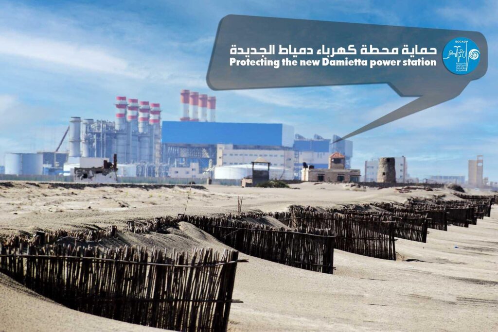
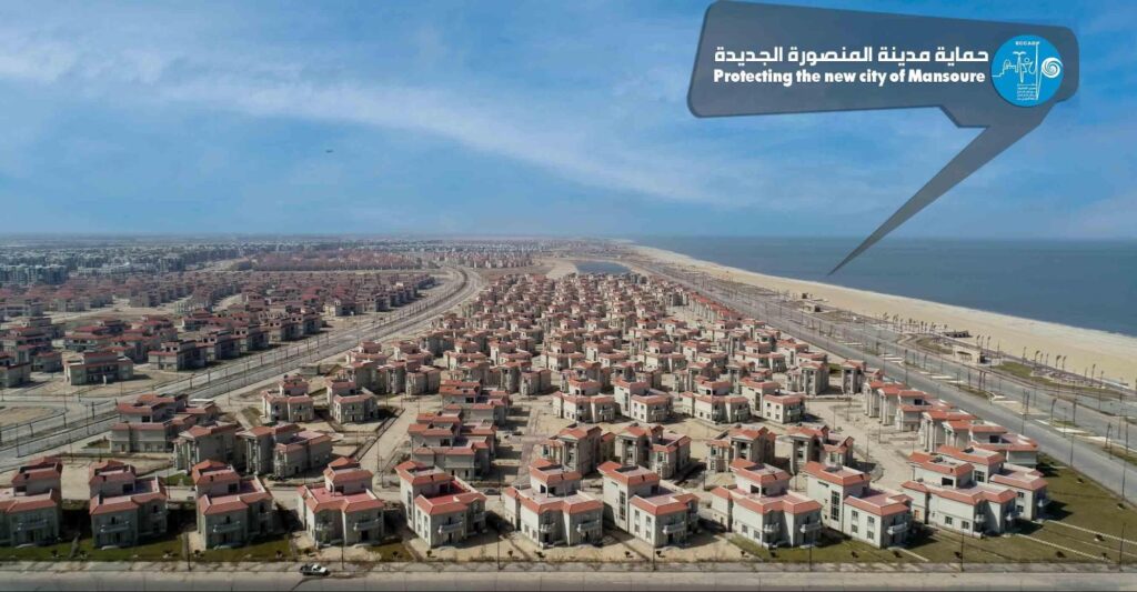
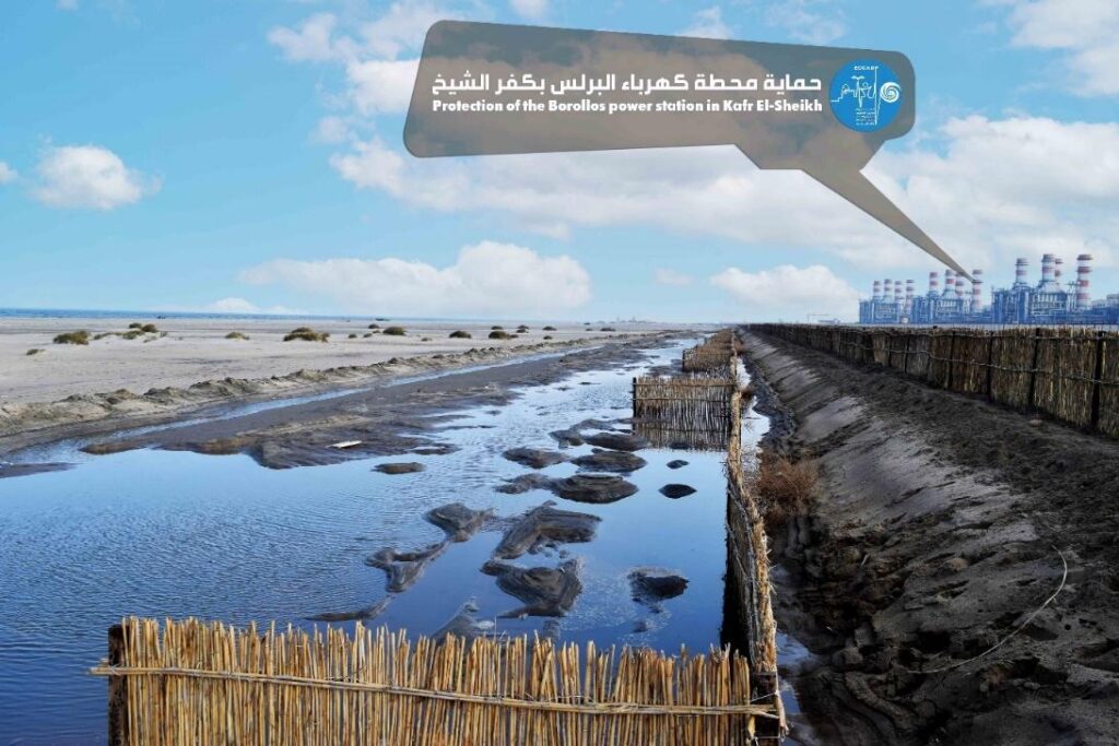
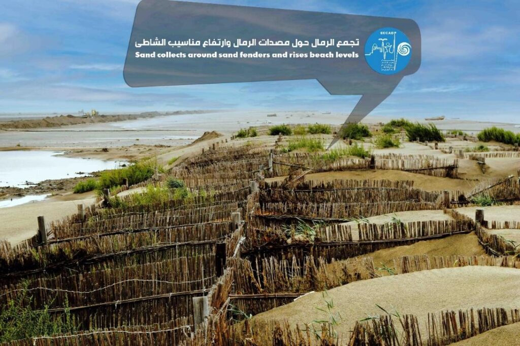
Figures 2-5: Selection of photos of shore protection from the project area ©ECCADP https://eccadp.com/
Documents
Brochure – Road to COP 27 (2021) A United Africa for a Resilient Future: https://www.undp.org/egypt/publications/brochure-road-cop-27
Video documentation
Using the power of nature to fight climate change in Egypt: https://www.youtube.com/watch?v=yL-n-3w4X94
Protecting communities in the Nile Delta from coastal flooding: https://www.youtube.com/watch?v=zJ6cbLiLbjc
Egypt Adapts to Climate Change: https://www.youtube.com/watch?v=xyppVqVSxSs
How is climate change threatening Egypt’s Nile Delta?: https://www.youtube.com/watch?v=D_UlJLapW0I
GCF in Egypt: An ecosystem-based approach to coastal protection: https://www.youtube.com/watch?v=GZ72C1QhsFQ