Geographic context and climate challenges
With some 447 km of coastline stretching along the Atlantic, the Strait of Gibraltar and the Mediterranean coast, the coastline of the Tangier-Tetouan-Al Hoceima (TTA) region boasts a unique geographical position, geomorphological structure and biological diversity (Agharroud et al., 2023). Overall, the TTA region benefits from a Mediterranean-type climate with hot, dry summers and mild, wet winters. Due to its geomorphological configuration with high Rif mountains and coastal plains, the TTA region is subject to diverse climatic conditions. Indeed, the oceanic influence, which characterizes the western basins of Loukkos and Tangier, is gradually attenuated in the Mediterranean coastal basins, with a pronounced aridity from West to East. In the western part between Larache and Oued Laou, the rainfall can exceed 700 mm/year, while the eastern part of the region (particularly for the lower basins located between Jebha and Al Hoceima) receives barely 400 mm/year. Temperatures are generally mild, but the region has been subject to a higher occurrence of heat waves in recent years, which further accentuates the negative impacts on people and natural resources (IPCC, 2022).
One of the mid to long-term projections (2041-2100) for coastal areas is that approximately one billion people will be at risk from coastal-related climate hazards under all IPCC scenarios. The World Bank has ranked Morocco’s coastal GDP in the Top 10 countries at risk with increasing storm surges. The climate-related risks for coastal communities are thus worrying for Morocco. The country is quickly developing, and its coastal areas are facing rapid population growth and urban development, particularly the TTA region (Ivčević et al., 2020). The coastline of the TTA region faces major societal and economic issues: population, industry and logistics, resort and tourism, fishing, agriculture, etc. It is home to high biodiversity and provides many ecosystem services. However, the shift of populations and activities from the hinterland to the coast, since the beginning of the 21st century, has contributed to a strong ‘artificialization’ of the coasts, making them more exposed to various meteorological and marine hazards, and consequently more vulnerable to coastal risks (Satta et al., 2016).
Objectives
Coastal plan TTA (French: Schéma Régional du Littoral) is a fundamental strategic document for ensuring consistency and better coordination of territorial sectoral planning, and for mobilizing and co-constructing a sustainable and integrated development framework for the TTA coastline. It is the fruit of an eminently participatory consultation process, involving all stakeholders active in the area of coastal planning zone, the majority of whom are members of the TTA region’s Commission Régionale de Gestion Intégrée du Littoral (CRGIL). The project of coastal plan TTA has been drawn up on the basis of the major issues and challenges arising from an in-depth diagnosis of the action zone, a forward-looking sustainability analysis, and a shared vision of the coastline up to 2045. It capitalizes on initiatives undertaken to develop synergy with other ongoing or projected plans and programs, and to “ensure the coherence of investment and equipment projects to be carried out by the State, local authorities and the private sector”, as provided for in Article 23 of the Coastal Act, and those programmed under the TTA Regional Development Program (2022-2027). It also helps to guide future investments and projects, in particular Morocco’s blue economy development program, which aims to integrate climate action into coastal tourism and fisheries management in targeted areas or where TTA region has been selected as a pilot site.
The alignment of proposed blue economy actions in the TTA region with the strategic objectives of the coastal plan TTA could maximize the positive impacts and coherence of the actions undertaken. These objectives also include preserving and restoring coastal ecosystems, promoting a green and sustainable economy, improving resilience to climate change, preserving natural and cultural heritage, promoting participatory governance and coordinating actions between different stakeholders. The coastal plan TTA represents an opportunity to establish a process for structuring genuine territorial governance. It is also a framework for promoting measures and operational projects. It must be a flexible, evolving instrument, always open to review in the light of evolving issues and updated projects.
Adaptation measures implemented in the case
Adaptation through integrated coastal zone management plans and programmes.
Solutions
The preparation of the Coastal Plan TTA was part of a larger UNEP/GEF project MedProgramme. It was developed based on Moroccan Law No. 81-12 (2015) on the coast, and the Mediterranean Protocol on Integrated Coastal Zone Management (ICZM). The preparation process started in 2021, with the plan finalized in April 2024, with the process of adoption by authorities still ongoing at the time of writing (as of July 2024). Among the Project activities, several were designed to contribute to the Coastal Plan TTA, such as:
- Climagine participatory method employed in 4 workshops, with Plan Bleu/RAC;
- Climate risk assessment of the coastal region TTA, with Plan Bleu/RAC;
- Interviews with 20 stakeholders, analysis and governance advice;
- Recommendations for future actions incorporating risk-related climate change mitigation and adaptation measures;
- Cost-benefit analysis of the selected adaptation options in the region TTA (still ongoing as of June 2024).
The Coastal Plan was prepared using the methodological guidelines for the preparation of the regional coastal plans in Morocco, in line with the standard ICZM planning process.
The territorial coastal plan zone coverage was determined according to expert knowledge and discussion with the stakeholders, in order not to be too large (whole province) nor too small (only municipality directly on the coastline). The option chosen is to consider both the communal division and source-to-sea coastal ecosystem functionalities, which is consistent both with the coastal law and ICZM principles, and in practice means including inland municipalities particularly along the river valleys (such as Loukkos).
The ongoing dialogue between experts and stakeholders within Climagine has made it possible, using a ‘funnel’ approach, to link the ideas and suggestions of Climagine participants with the coastal plan TTA development process. This work brought a common vision of the TTA coastline 2045 as “ecologically productive, legally protected, economically enhanced, socially equitable, and resilient to climate change”. Also, the priorities of the coastal plan TTA were established by the stakeholders and include: coastline (spatial planning, use of space and sustainable spatial development), green and blue economy, risks and pollution, water, equitable society, and governance, all examined through the prism of climate change.
The climate risk assessment of the coastal region TTA was done using the coastal risk index application at the local scale methodology (Agharroud et al., 2023) and the results show that coastal hazard zone of the TTA region is extremely exposed to coastal forcing, with more than 50% of the highly vulnerable zones in the most populated urban zones. More precisely, the hotspots zones in terms of climate change-related coastal risks are located at Tangier Bay, south of Tangier city, Fnideq-Martil coastline, Tetouan city, and north of Ksar el Kbir city, which is a useful information for the policy-makers in their work of coastal planning and management.
The success of regional coastal planning and the ICZM protocol was questioned in a series of interviews with the stakeholders from CRGIL, which served to produce advice on governance structure of the coastal plan TTA in light of climate change. A governance structure with three boards was proposed for the case of the TTA: a restricted group of Steering Institutions, consisting of the six most integrating and relevant regional bodies, a group of territorial Administrations, and an Advice board – broad panel of sectoral, scientific, and civil society members. The effort of reinforcing governance structure is needed so that the coastal plan does not remain only a document on the shelf, without impact in strategic coastal development.
Recommendations for future actions incorporating risk-related climate change mitigation and adaptation measures were listed, both socio-political and technical ones, following the strategic and operational objectives. In addition, recommendations regarding spatial development and the coherence between different documents related to urbanisms and coastal plan TTA, are proposed. Finally, the action plan was prepared that forms part of an integrated and coherent approach at all levels of administration and regional governance. This plan reflects National Sustainable Development Strategy and is aligned with Morocco’s commitment to international conventions and the Sustainable Development Goals.
Leader of the initiative and key partners
In Morocco, the Department of the Environment is responsible for ICZM projects, and implements this approach through actions and projects with partners at local, national, regional and international levels, regional and international levels.
The provisions of the ‘Littoral’ law and its decree, adopted in 2015 in Morocco, are perfectly aligned with those of the ICZM Protocol of the Barcelona Convention, which Morocco ratified in 2012. Thus, in line with this legislation, and as part of the project to draw up the Coastal Plan TTA Region, an Arrêté creating the Commission Régionale de Gestion Intégrée du Littoral de la Région TTA (CRGIL) was signed by the Wali of the Region on September 21, 2021. This demonstrates the successful integration of the Coastal Plan TTA with the ‘Littoral’ law in Morocco.
The CRGIL, a list of 65 stakeholder institutions from the region TTA, whose main mission is to ensure the successful steering and concerted implementation of the Coastal Plan TTA, is to:
- Oversee all stages of Coastal Plan TTA preparation and implementation;
- Coordinate with all stakeholders involved in Integrated Coastal Management;
- Develop financial instruments to implement the actions set out in the Coastal Plan TTA;
- Advise on projects, studies and policy documents that have an impact on integrated coastal impact on integrated coastal management;
- Propose a program of work and measures to protect the coastline and combat environmental degradation, particularly in the face of climate change.
Once the Coastal Plan is completed and adopted by both regional and national authorities, the Region TTA will remain the leader of the initiative. The governance will be organized with the CRGIL. The CRGIL will meet as need occurs, but not less than once a year, to coordinate the implementation of the Coastal Plan. PAP/RAC, the organization that led the preparation of the Coastal Plan TTA, continues to provide support to the Regional Government (particularly to the Regional Directorate of Environment, DRE TTA) participating in the TTA’s CRGIL meetings and jointly implementing other projects.
Stakeholder participation
Well-conducted consultation is a guarantee of a shared vision, active mobilisation of stakeholders, and facilitates the process of adopting the coastal plan TTA. It is particularly valuable in the case of an administrative entity as diverse as the TTA region, where coastal uses are multiple and complex. A participatory and holistic approach to the management and development of the coast, considering its environmental, institutional, socio-economic and cultural aspects, and involving the stakeholders concerned, can facilitate the process of drawing up and implementing the coastal plan. Climagine, the participatory foresight method developed by the Plan Bleu/RAC, applied throughout the coastal plan TTA development process, addresses the specific challenges of climate change in coastal zones.
In Morocco, the majority of stakeholders involved in the Climagine process are members of the CRGIL TTA. Through an integrated cycle of workshops organised to support the development of the coastal plan TTA, Climagine has brought together decision-makers and public institutions working at national, regional and local levels, as well as scientific institutions, coastal managers, representatives of civil society, port authorities and environmental protection agencies. In the TTA region, Climagine was structured around 4 participatory workshops organised in Tangiers in 2022-2023, held following the coastal plan meetings led by PAP/RAC and its national experts. Between each workshop, the experts took up the main results and messages of the workshops, in order to relate them to existing data and bibliographical resources of the territory TTA. This ongoing dialogue between experts and stakeholders has made it possible, using a ‘funnel’ approach, to link the ideas and suggestions of Climagine participants with the coastal plan TTA development process.
During the first stage ‘Reflecting and understanding’ (16 March 2022), stakeholders worked to establish a shared vision for the TTA region. Sustainability Indicators for each priority area of the coastal plan TTA identified by stakeholders are then developed (‘Making connections and investigating’, 29-30 September 2023), and Band of Equilibrium was defined (‘Modelling and exploration’, 8 March 2023). Finally, ‘Making and suggesting’ (21 June 2023) workshop involved the experts drawing up ‘amoeba’ diagrams to visualise the socio-economic and ecological situation in the coastal plan area. These diagrams summarise the results and describe the current state, the future trend scenario and the alternative scenario for the socio-economic and ecological development of the TTA region’s coastline.
Success and limiting factors
Although Morocco has a strong capacity to implement ICZM, including a fairly comprehensive legal framework (Coastal Law) compatible with the ICZM Protocol, the obstacles remain. Among them is the administrative fragmentation and lack of implementation of coastal protection and conservation measures, or the application of restrictions to coastal development. The preconditions necessary for the implementation of ICZM are mostly in place. However, the main weaknesses and gaps are mainly in the progress towards a national ICZM strategy or plan, in line with the ICZM Protocol strategy or plan in line with the ICZM Protocol, and in the full adoption and implementation of the Coastal Law. The implementation and integration on the ground remains relatively weak. The lack of a legal and institutional framework for the governance of groundwater in general, and coastal aquifers in particular, seriously threatens the environmental and socio-economic environmental and socio-economic viability of large parts of the coastal zone.
Coastal plan TTA is one of three coastal plans that integrate climate action funded by GEF MedProgramme, in addition to Montenegro and Lebanon. Three key success factors of the Coastal Plan TTA are the following:
- strong legal background for the regional coastal plans (Schémas Régionaux du Littoral) in Morocco – recognized and mandatory by the Moroccan Law No. 81-12 (2015) on the coast – which gives visibility and a sense of importance for the ICZM and sustainable development of the Moroccan coasts;
- a successful participatory process led by Plan Bleu/RAC experts which enabled the creation of a sense of the importance of coastal planning, treating the selected priority topics through the prism of climate change, and embracing and translating the local knowledge and expertise into the coastal plan TTA;
- a committed approach of the Moroccan team of experts led by PAP/RAC that resulted in relevant reports and a final, high-quality document of the coastal plan TTA.
Finally, PAP/RAC team is continuing the support for the implementation phase of the coastal plan TTA, as well as with the reinforcement of the governance structure that will help the plan continue its life reinforcing the TTA coastline after the project ends.
Costs and benefits
At the Region TTA several members of the staff from the Regional Directorate of the Environment were more deeply involved in the activity of the coastal plan TTA because DRE TTA plays the role of the Secretariat of the CRGIL. Four workshops were organized by the DRE TTA and international partners from PAP/RAC, Plan Bleu/RAC and GWP-Med with the average participation of 72 persons per workshop.
The preparation of the coastal plans is the most demanding activity of the GEF MedProgramme at PAP/RAC, with four staff members involved with different tasks and allocations in four different countries. In addition, the technical resources for the coastal plan TTA consisted of an expert team led by PAP/RAC and composed of a national team leader and expert for ICZM and risks, a spatial planner, an expert for socio-economic questions, an expert for governance and climate adaptation, and a GIS specialist. Punctual and additional engagement in the coastal plan TTA preparation included a sociologist, experts in geodesy and land use change, and a team of environmental economists.
As for the financial resources, the GEF MedProgramme, both CP2.1 and SCCF projects, support was of cca USD 200,000. The regional administration DRE TTA and PAP/RAC provided co-financing in-kind through the work of their human/technical resources, and the regional administration DRE TTA secured human resources, premises and equipment for meetings, and a vehicle for field visits. The coastal plan TTA benefited from the parallel activities by Plan Bleu/RAC and GWP-MED implemented with separate financing but within the same project GEF MedProgramme.
Regarding benefits, the coastal plan TTA – as a strategic document in the field of planning – gives the vision for the coastal parts of the region TTA until 2045 and serves as a reference for all the documents of urbanism that will have to take into consideration the coastal plan TTA. At the heart of the ICZM approach adopted is the need to reconcile and integrate sectoral policies at the regional level. This integration is essential to ensure that local and regional efforts are not only aligned with national strategies but are also complementary and synergistic with the SRAT, PDR, PCT, SDAU and others. Harmonising the interventions of various actors at the local level is crucial to maximising the effectiveness and impact of development initiatives.
In the specific context of Morocco, the organisation of major international sporting events, such as the African Cup in 2025 and the World Cup in 2030, represents exceptional opportunities for the country. These events offer a unique platform to showcase Morocco’s potential while stimulating economic and social development. It is therefore crucial that the coastal plan TTA with the action plan incorporates specific strategies to optimise these opportunities, ensuring that the programmes and projects put in place contribute to the country’s long-term objectives, to ensure that the efforts deployed contribute effectively to the achievement of sustainable and inclusive development, for the benefit of the entire population. To effectively translate the objectives and aspirations of the coastal plan TTA into concrete actions, the action plan provides a clear, structured overview of the initiatives to be undertaken, making it easier to monitor and understand the logic behind the formulation of actions that will provide direct benefits in key management policies in the region TTA.
Implementation time and lifetime
The coastal plan TTA, or in Morocco Schéma Régional du Littoral (Regional Coastal Plan) is a regulatory document instituted by Law No. 81-12 (2015) on the coast, with a view to its protection, enhancement and conservation. This law is in line with the guidelines of the ICZM Protocol of the Barcelona Convention. With a maximum lifespan of 20 years, the coastal plan TTA is the result of a participatory process of planning and sustainable management of coastal resources and conservation of coastal ecosystems. The coastal plan SRL is the second coastal plan in Morocco, the initial preparation of which began in June 2021. The first workshop was organised in March 2022, and the first draft of the document was prepared in November 2023. After the reception of the comments and remarks by the stakeholders, the coastal plan TTA was finalized in April 2024. As of July 2024, the document is in the process of adoption by Moroccan regional and national authorities. If adopted by the end of 2024, its validity will be until the year 2045.
Contacts
Mohammed AMRANI
Chef du Service de l’Observatoire Régional de l’Environnement et du Développement Durable
Direction Régionale de l’Environnement – Région Tanger Tétouan Al Hoceima
Immeuble NREA n°183, angle Avenue Prince Héritier et rue Jabir Tabari, 2ème étage n°48 – 90 000 Tanger
Source for more detailed information
Agharroud K, Puddu M, Ivčević A, Satta A, Kolker AS and Snoussi M (2023) Climate risk assessment of the Tangier-Tetouan-Al Hoceima coastal Region (Morocco). Front. Mar. Sci. 10:1176350. doi: 10.3389/fmars.2023.1176350
IPCC. (2022). “Summary for policymakers,” in Climate change 2022: impacts, adaptation and vulnerability. contribution of working group II to the sixth assessment report of the intergovernmental panel on climate change. Eds. H.-O. Pörtner, D. C. Roberts, E. S. Poloczanska, K. Mintenbeck, M. Tignor, A. Alegrıa, M. Craig, S. Langsdorf, S. Löschke, V. Möller and A. Okem (Cambridge, UK and New York, NY, USA: Cambridge University Press), 3–33. doi: 10.1017/9781009325844.001
Ivčević, A., Bertoldo, R., Mazurek, H., Siame, L., Guignard, S., Moussa, A. B., et al. (2020). Local risk awareness and precautionary behaviour in a multi-hazard region of north Morocco. Int. J. Disaster Risk Reduct. 50, 101724. doi: 10.1016/j.ijdrr.2020.101724
Satta, A., Snoussi, M., Puddu, M., Flayou, L., and Hout, R. (2016). An index-based method to assess risks of climate-related hazards in coastal zones: the case of Tetouan. Estuar. Coast. Shelf Sci. 175, 93–105. doi: 10.1016/j.ecss.2016.03.021
Map

Pictures
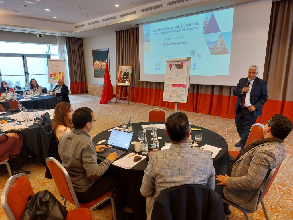
Figure 1: First, inception coastal plan TTA workshop in Tangier, Morocco (March 2022)
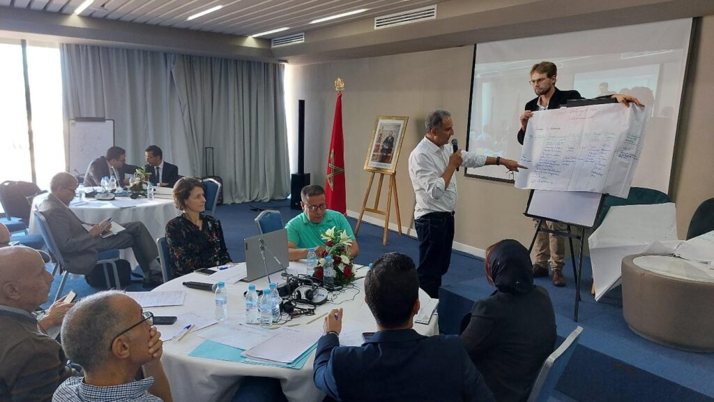
Figure 2: Second coastal plan TTA workshop, restitution after the participative Climagine group work.
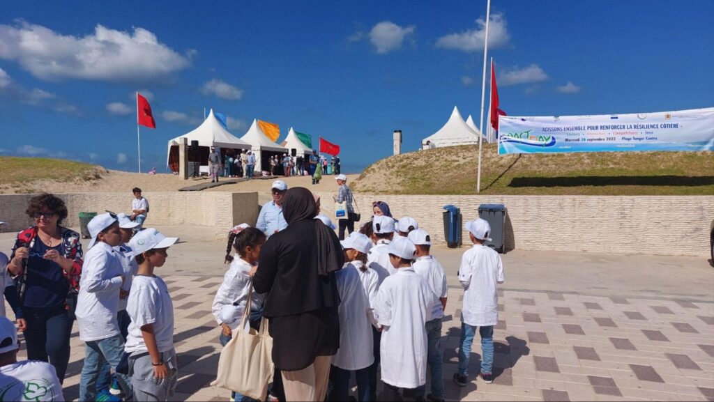
Figure 3: Dissemination of the knowledge and good practice about coastal resilience, activities for the central Coast Day celebration organized in Tangier, Morocco in September 2022, within MedProgramme. © Ante Ivcevic
Documents
Brochure SRL TTA
Coastal Plan SRL TTA draft version